2 Geologic View of Time
Physical Weathering
Intrusive igneous rocks form at depths of several hundreds of metres to several tens of kilometres. Sediments are turned into sedimentary rocks only when they are buried by other sediments to depths in excess of several hundreds of metres. Most metamorphic rocks are formed at depths of kilometres to tens of kilometres. Weathering cannot even begin until these rocks are uplifted through various processes of mountain building—most of which are related to plate tectonics—and the overlying material has been eroded away and the rock is exposed as an outcrop. (To a geologist, an outcrop is an exposure of bedrock, the solid rock of the crust.)
The most important agents of physical weathering are:
- The decrease in pressure that results from removal of overlying rock
- Freezing and thawing of water in cracks in the rock
- Formation of salt crystals within the rock
- Cracking from plant roots and removal of material by burrowing animals
When a mass of rock is exposed by weathering and removal of the overlying rock, there is a decrease in the confining pressure on the rock, and the rock expands. This unloading promotes cracking of the rock, known as exfoliation, as shown in the granitic rock in Figure 5.1.1., which, in places, is peeling off like the layers of an onion.
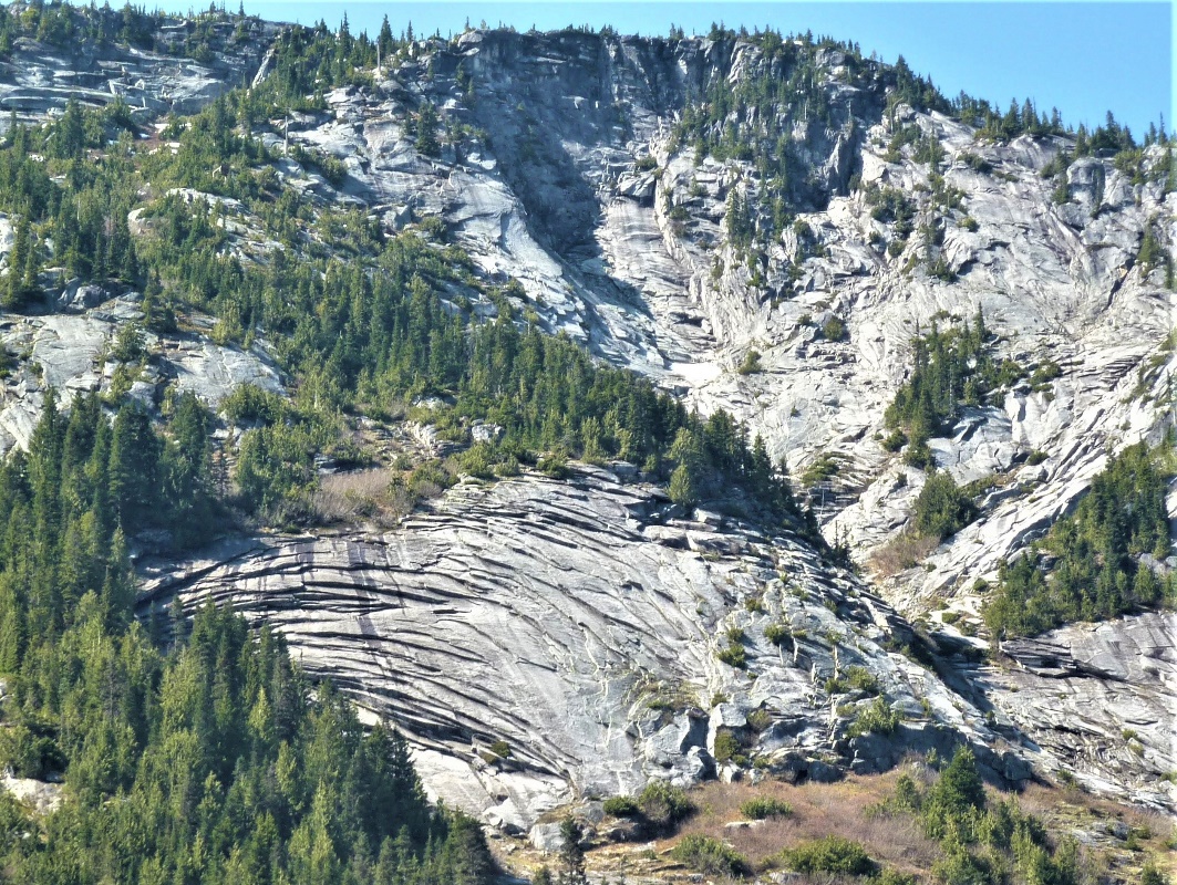
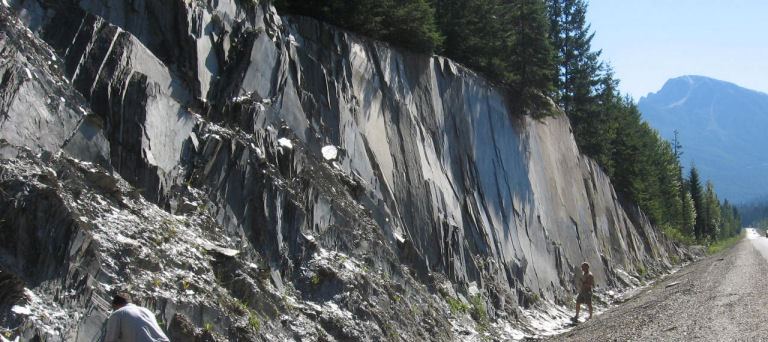
Granitic rock tends to exfoliate parallel to the exposed surface because the rock is typically homogenous, and it doesn’t have predetermined planes along which it must fracture. Sedimentary and metamorphic rocks, on the other hand, tend to exfoliate along predetermined planes (Figure 5.1.2).
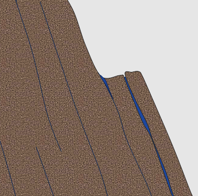
Frost wedging is the process by which water seeps into cracks in a rock, expands on freezing, and thus enlarges the cracks (Figure 5.1.3). The effectiveness of frost wedging is related to the frequency of freezing and thawing. In warm areas where freezing is infrequent, in very cold areas where thawing is infrequent, or in very dry areas, where there is little water to seep into cracks, the role of frost wedging is limited.
A related process, frost heaving, takes place within unconsolidated materials on gentle slopes. In this case, water in the soil freezes and expands, pushing the overlying material up. Frost heaving is responsible for winter damage to roads all over North America.
When salt water seeps into rocks and then evaporates on a hot sunny day, salt crystals grow within cracks and pores in the rock. The growth of these crystals exerts pressure on the rock and can push grains apart, causing the rock to weaken and break.
The effects of plants and animals are significant in physical weathering. Roots can force their way into even the tiniest cracks, and then they exert tremendous pressure on the rocks as they grow, widening the cracks and breaking the rock (Figure 5.1.4). Although animals do not normally burrow through solid rock, they can excavate and remove huge volumes of soil, and thus expose the rock to weathering by other mechanisms.
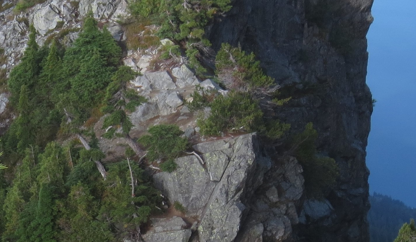
Physical weathering is greatly facilitated by erosion, which is the removal of weathering products, allowing for the exposure of more rock for weathering. On the steep rock faces at the top of the cliff, rock fragments have been broken off by ice wedging, and then removed by gravity. This is a form of mass wasting. Other important agents of erosion that also have the effect of removing the products of weathering include water in streams, glacial ice, and waves on the coasts.
Chemical Weathering
Chemical weathering results from chemical changes to minerals that become unstable when they are exposed to surface conditions. The kinds of changes that take place are highly specific to the mineral and the environmental conditions. Some minerals, like quartz, are virtually unaffected by chemical weathering, while others, like feldspar, are easily altered. In general, the degree of chemical weathering is greatest in warm and wet climates, and least in cold and dry climates. The important characteristics of surface conditions that lead to chemical weathering are the presence of water (in the air and on the ground surface), the abundance of oxygen, and the presence of carbon dioxide, which produces weak carbonic acid when combined with water. That process, which is fundamental to most chemical weathering, can be shown as follows:
H2O + CO2 ↔ H2CO3 then H2CO3 ↔ H+ + HCO3−
water + carbon dioxide ↔ carbonic acid
then
carbonic acid ↔ dissolved hydrogen ions + dissolved bicarbonate ions
Yikes! Chemical formulas
Lots of people seize up when they are asked to read chemical or mathematical formulas. It’s OK, you don’t necessarily have to! If you don’t like the formulas just read the text underneath them. In time you may get used to reading the formulas.
The double-ended arrow “↔ ” indicates that the reaction can go either way, but for our purposes these reactions are going towards the right.
Here we have water (e.g., as rain) plus carbon dioxide in the atmosphere, combining to create carbonic acid. Then carbonic acid dissociates (comes apart) to form hydrogen and bicarbonate ions. The amount of CO2 in the air is enough to make weak carbonic acid. There is typically much more CO2 in the soil, so water that percolates through the soil can become more acidic. In either case, this acidic water is a critical to chemical weathering.
In some types of chemical weathering the original mineral becomes altered to a different mineral. For example, feldspar is altered—by hydrolysis—to form clay minerals plus some ions in solution. In other cases the minerals dissolve completely, and their components go into solution. For example, calcite (CaCO3) is soluble in acidic solutions.
The hydrolysis of feldspar can be written like this:
CaAl2Si2O8 + H2CO3 + ½O2 ↔ Al2Si2O5(OH)4 +Ca2+ + CO32−
plagioclase feldspar + carbonic acid ↔ kaolinite + dissolved calcium ions + dissolved carbonate ions
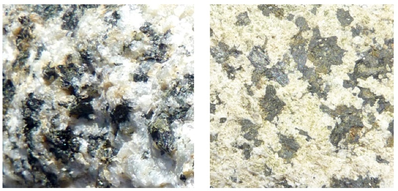
This reaction shows calcium-bearing plagioclase feldspar, but similar reactions could also be written for sodium or potassium feldspars. In this case, we end up with the mineral kaolinite, along with calcium and carbonate ions in solution. Those ions can eventually combine (probably in the ocean) to form the mineral calcite. The hydrolysis of feldspar to clay is illustrated in Figure 5.2.1, which shows two images of the same granitic rock, a recently broken fresh surface on the left and a clay-altered weathered surface on the right. Other silicate minerals can also go through hydrolysis, although the end results will be a little different. For example, pyroxene can be converted to the clay minerals chlorite or smectite, and olivine can be converted to the clay mineral serpentine.
Oxidation is another very important chemical weathering process. The oxidation of the iron in a ferromagnesian silicate starts with the dissolution of the iron. For olivine, the process looks like this, where olivine in the presence of carbonic acid is converted to dissolved iron, carbonate, and silicic acid:
Fe2SiO4+ 4H2CO3 ↔ 2Fe2+ + 4HCO3− + H4SiO4
olivine + (carbonic acid) ↔ dissolved iron ions + dissolved carbonate ions + dissolved silicic acid
But in the presence of oxygen and carbonic acid, the dissolved iron is then quickly converted to the mineral hematite:
2Fe2+ + 4HCO3− + ½ O2 + 2H2O ↔ Fe2O3 + 4H2CO3
dissolved iron ions + dissolved bicarbonate ions + oxygen + water ↔ hematite + carbonic acid
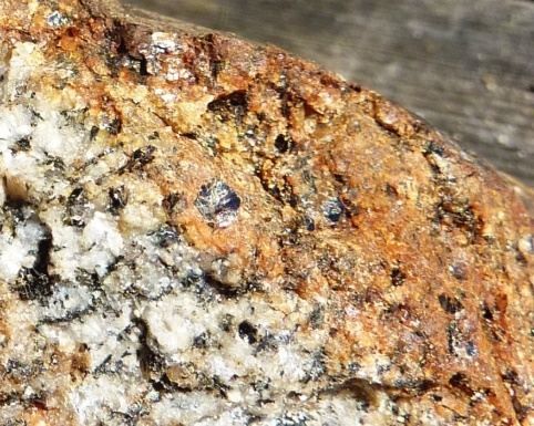
The equation shown here is for olivine, but it could apply to almost any other ferromagnesian silicate, including pyroxene, amphibole, or biotite. Iron in the sulphide minerals (e.g., pyrite) can also be oxidized in this way. And the mineral hematite is not the only possible end result, as there is a wide range of iron oxide minerals that can form in this way. The results of this process are illustrated in Figure 5.2.2, which shows a granitic rock in which some of the biotite and amphibole have been altered to form the iron oxide mineral limonite.
A special type of oxidation takes place in areas where the rocks have elevated levels of sulphide minerals, especially pyrite (FeS2). Pyrite reacts with water and oxygen to form sulphuric acid:
2FeS2 + 7O2 + 2H2O ↔ 2Fe2+ H2SO4 + 2H+
pyrite + oxygen + water ↔ dissolved iron ions + sulphuric acid + dissolved hydrogen ions
The hydrolysis of feldspar and other silicate minerals and the oxidation of iron in ferromagnesian silicates all serve to create rocks that are softer and weaker than they were to begin with, and thus more susceptible to physical weathering.
The weathering reactions that we’ve discussed so far involved the transformation of one mineral to another mineral (e.g., feldspar to clay), and the release of some ions in solution (e.g., Ca2+ or Fe2+). Some weathering processes involve the complete dissolution of a mineral. Calcite, for example, will dissolve in weak acid, to produce calcium and bicarbonate ions. The equation is as follows:
CaCO3 + H+ + HCO3− ↔ Ca2+ + 2HCO3−
calcite + dissolved hydrogen ions + dissolved bicarbonate ions ↔ dissolved calcium ions + dissolved bicarbonate ions
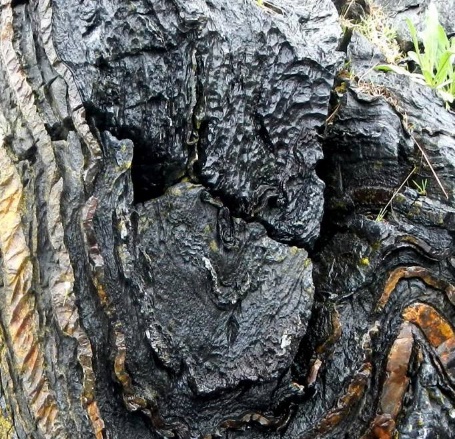
Calcite is the major component of limestone (typically more than 95%), and under surface conditions, limestone can dissolve completely, as shown in Figure 5.2.4. Limestone also dissolves at relatively shallow depths underground, forming limestone caves.
Deposition
Sediments accumulate in a wide variety of environments, both on the continents and in the oceans. Some of the more important of these environments are illustrated in Figure 6.3.1.
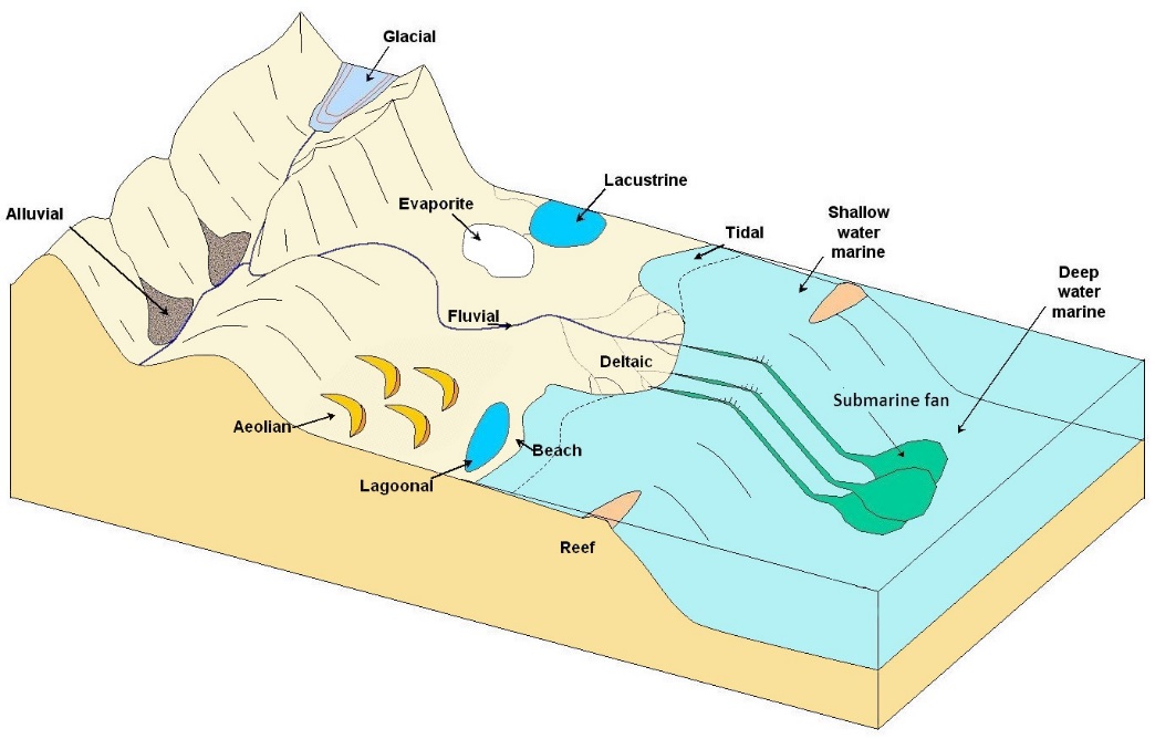
Table 6.4 provides a summary of the processes and sediment types that pertain to the various depositional environments illustrated in Figure 6.3.1. The characteristics of these various environments, and the processes that take place within them, will be expanded upon when we look at national parks that have glaciation, mass wasting, streams and coasts.
Table 6.4 The important terrestrial depositional environments and their characteristics
|
Environment |
Important transport processes |
Depositional environments |
Typical sediment types |
|---|---|---|---|
|
Glacial |
gravity, moving ice, moving water |
valleys, plains, streams, lakes |
glacial till, gravel, sand, silt, and clay |
|
Alluvial |
gravity |
steep-sided valleys |
coarse angular fragments |
|
Fluvial |
moving water |
streams |
gravel, sand, silt, and organic matter (in swampy parts only) |
|
Aeolian |
wind |
deserts and coastal regions |
sand, silt |
|
Lacustrine |
moving water (flowing into a lake) |
lakes |
sand (near the edges only), silt, clay, and organic matter |
|
Evaporite |
moving water (flowing into a lake) |
lakes in arid regions |
salts, clay |
Table 6.5 The important marine depositional environments and their characteristics
|
Environment |
Important Transport Processes |
Depositional Environments |
Typical Sediment Types |
|---|---|---|---|
|
Deltaic |
moving water |
deltas |
sand, silt, clay, and organic matter (in swampy parts only) |
|
Beach |
waves, longshore currents |
beaches, spits, sand bars |
gravel, sand |
|
Tidal |
tidal currents |
tidal flats |
silt, clay |
|
Reefs |
waves and tidal currents |
reefs and adjacent basins |
carbonates |
|
Shallow water marine |
waves and tidal currents |
shelves and slopes, lagoons |
carbonates in tropical climates, sand/silt/clay elsewhere |
|
Lagoonal |
little transportation |
lagoon bottom |
carbonates in tropical climates |
|
Submarine fan |
underwater gravity flows |
continental slopes and abyssal plains |
gravel, sand, mud |
|
Deep water marine |
ocean currents |
deep-ocean abyssal plains |
clay, carbonate mud, silica mud |
Most of the sediments that you might see around you, including talus on steep slopes, sand bars in streams, or gravel in road cuts, will never become sedimentary rocks because they have only been deposited relatively recently—perhaps a few centuries or millennia ago—and are likely to be re-eroded before they are buried deep enough beneath other sediments to be lithified. In order for sediments to be preserved long enough to be turned into rock—a process that takes millions or tens of millions of years—they need to have been deposited in a basin that will last that long. Most such basins are formed by plate tectonic processes.
Stream Erosion and Deposition
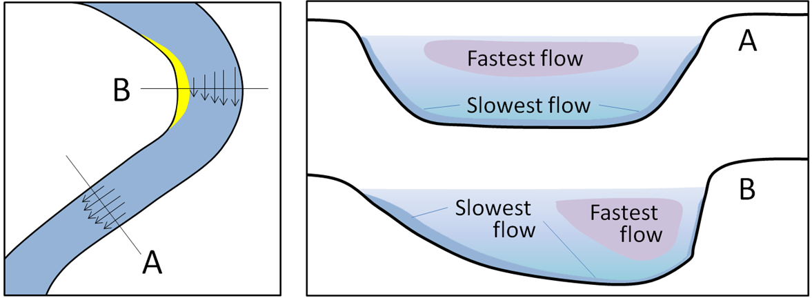
Flowing water is a very important mechanism for erosion, transportation and deposition of sediments. Water flow in a stream is primarily related to the stream’s gradient, but it is also controlled by the geometry of the stream channel. As shown in Figure 13.3.1, water flow velocity is decreased by friction along the stream bed, so it is slowest at the bottom and edges and fastest near the surface and in the middle. In fact, the velocity just below the surface is typically a little higher than right at the surface because of friction between the water and the air. On a curved section of a stream, flow is fastest on the outside and slowest on the inside.
Other factors that affect stream-water velocity are the size of sediments on the stream bed—because large particles tend to slow the flow more than small ones—and the discharge, or volume of water passing a point in a unit of time (e.g., cubic metres (m3) per second). During a flood, the water level always rises, so there is more cross-sectional area for the water to flow in, however, as long as a river remains confined to its channel, the velocity of the water flow also increases.
Figure 13.3.2 shows the nature of sediment transportation in a stream. Large particles rest on the bottom—bed load—and may only be moved during rapid flows under flood conditions. They can be moved by saltation (bouncing) and by traction (being pushed along by the force of the flow).
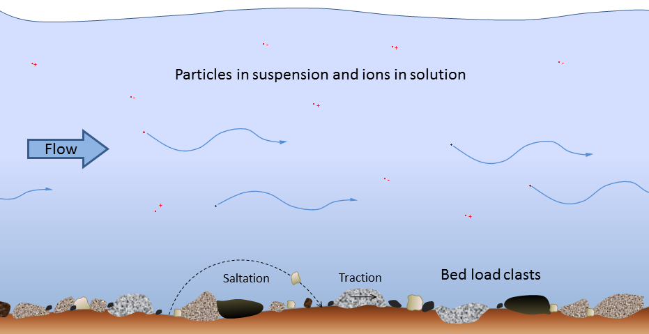
Smaller particles may rest on the bottom some of the time, where they can be moved by saltation and traction, but they can also be held in suspension in the flowing water, especially at higher velocities. Streams that flow fast tend to be turbulent (flow paths are chaotic and the water surface appears rough) and the water may be muddy, while those that flow more slowly tend to have laminar flow (straight-line flow and a smooth water surface) and clear water. Turbulent flow is more effective than laminar flow at keeping sediments in suspension.
Stream water also has a dissolved load, which represents (on average) about 15% of the mass of material transported, and includes ions such as calcium (Ca+2) and chloride (Cl−) in solution. The solubility of these ions is not affected by flow velocity.
It is important to be aware that a stream can both erode and deposit sediments at the same time. At 100 cm/s, for example, silt, sand, and medium gravel will be eroded from the stream bed and transported in suspension, coarse gravel will be held in suspension, pebbles will be both transported and deposited, and cobbles and boulders will remain stationary on the stream bed.
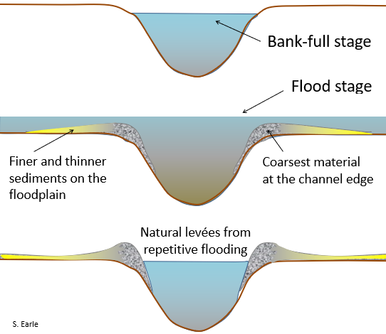
A stream typically reaches its greatest velocity when it is close to flooding over its banks. This is known as the bank-full stage, as shown in Figure 13.3.4. As soon as the flooding stream overtops its banks and occupies the wide area of its flood plain, the water has a much larger area to flow through and the velocity drops significantly. At this point, sediment that was being carried by the high-velocity water is deposited near the edge of the channel, forming a natural bank or levée.
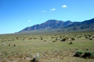
Desert Weathering and Erosion
Weathering takes place in desert climates by the same means as other climates, only at a slower rate. While higher temperatures typically spur faster chemical weathering, water is the main agent of weathering, and lack of water slows both physical and chemical weathering. Low precipitation levels also mean less runoff as well as ice wedging. When precipitation does occur in the desert, it is often heavy and may result in flash floods in which a lot of material may be dislodged and moved quickly.
One unique weathering product in deserts is desert varnish. Also known as desert patina or rock rust, this is thin dark brown layers of clay minerals and iron and manganese oxides that form on very stable surfaces within arid environments. The exact way this material forms is still unknown, though cosmogenic and biologic mechanisms have been proposed.
While water is still the dominant agent of erosion in most desert environments, wind is a notable agent of weathering and erosion in many deserts. This includes suspended sediment traveling in haboobs, or large dust storms, that frequent deserts. Deposits of windblown dust are called loess. Loess deposits cover wide areas of the midwestern United States, much of it from rock flour that melted out of the ice sheets during the last ice age. Loess was also blown from desert regions in the West. Possessing lower energy than water, wind transport nevertheless moves sand, silt, and dust. The load carried by a fluid (air is a fluid like water) is distributed among bedload and suspended load. As with water, in wind these components depend on wind velocity.
Sand size material moves by a process called saltation in which sand grains are lifted into the moving air and carried a short distance where they drop and splash into the surface dislodging other sand grains which are then carried a short distance and splash dislodging still others
Saltation is a cascading effect of sand movement creating a zone of wind-blown sand up to a meter or so above the ground. This zone of saltating sand is a powerful erosive agent in which bedrock features are effectively sandblasted. The fine-grained suspended load is effectively sorted from the sand near the surface carrying the silt and dust into haboobs. Wind is thus an effective sorting agent separating sand and dust sized (≤70 µm). When wind velocity is high enough to slide or roll materials along the surface, the process is called creep.
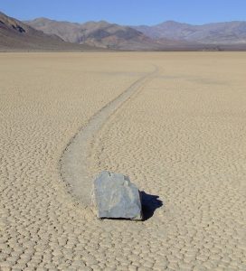
One extreme version of sediment movement was shrouded in mystery for years: Sliding stones. also called sailing stones and sliding rocks, are large boulders that move along flat surfaces in deserts, leaving trails. This includes the famous example of the Racetrack Playa in Death Valley National Park, California. For years, scientists and enthusiasts attempted to explain their movement, with little definitive results. In recent years, several experimental and observational studies have confirmed that the stones, imbedded in thin layers of ice, are propelled by friction from high winds. These studies include measurements of actual movement, as well as re-creations of the conditions, with resulting movement in the lab.
The zone of saltating sand is an effective agent of erosion through sand abrasion. A bedrock outcrop which has such a sandblasted shape is called a yardang.
Rocks and boulders lying on the surface may be blasted and polished by saltating sand. When predominant wind directions shift, multiple sandblasted and polished faces may appear. Such wind abraded desert rocks are called ventifacts.
Winds may be sufficient to remove materials not anchored by vegetation. The bowl-shaped depression remaining on the surface is called a blowout.
Desert Landforms
In the American Southwest, as streams emerge into the valleys from the adjacent mountains, they create desert landforms called alluvial fans. When the stream emerges from the narrow canyon, the flow is no longer constrained by the canyon walls and spreads out. At the lower slope angle, the water slows down and drops its coarser load. As the channel fills with this conglomeratic material, the stream is deflected around it. This deposited material deflects the stream into a system of radial distributary channels in a process similar to how a delta is made by a river entering a body of water. This process develops a system of radial distributaries and constructs a fan shaped feature called an alluvial fan.
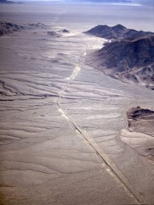
Alluvial fans continue to grow and may eventually coalesce with neighboring fans to form an apron of alluvium along the mountain front called a bajada.
As the mountains erode away and their sediment accumulates first in alluvial fans, then bajadas, the mountains eventually are buried in their own erosional debris. Such buried mountain remnants are called inselbergs, “island mountains.”
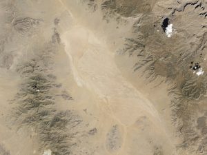
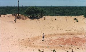
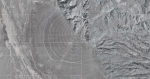
Where the desert valley is an enclosed basin, i.e. streams entering it do not drain out, the water is removed by evaporation and a dry lake bed is formed called a playa.
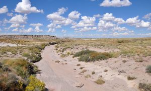
Playas are among the flattest of all landforms. Such a dry lake bed may cover a large area and be filled after a heavy thunderstorm to only a few inches deep. Playa lakes and desert streams that contain water only after rainstorms are called intermittent or ephemeral. Because of intense thunderstorms, the volume of water transported by ephemeral drainage in arid environments can be substantial during a short period of time. Desert soil structures lack organic matter that promotes infiltration by absorbing water. Instead of percolating into the soil, the runoff compacts the ground surface, making the soil hydrophobic or water-repellant. Because of this hardpan surface, ephemeral streams may gather water across large areas, suddenly filling with water from storms many miles away.
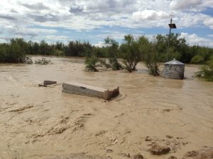
High-volume ephemeral flows, called flash floods, may move as sheet flows or sheetwash, as well as be channeled through normally dry arroyos or canyons. Flash floods are a major factor in desert deposition. Dry channels can fill quickly with ephemeral drainage, creating a mass of water and debris that charges down the arroyo, and even overflowing the banks. Flash floods pose a serious hazard for desert travelers because the storm activity feeding the runoff may be miles away. People hiking or camping in arroyos that have been bone dry for months, or years, have been swept away by sudden flash floods.
Dune Types
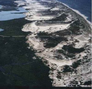
Dunes are complex features formed by a combination of wind direction and sand supply, in some cases interacting with vegetation. There are several types of dunes representing variables of wind direction, sand supply and vegetative anchoring. Barchan dunes or crescent dunes form where sand supply is limited and there is a fairly constant wind direction. Barchans move downwind and develop a crescent shape with wings on either side of a dune crest. Barchans are known to actually move over homes, even towns.
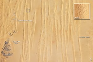
Longitudinal dunes or linear dunes form where sand supply is greater and the wind blows around a dominant direction, in a back-and-forth manner. They may form ridges tens of meters high lined up with the predominant wind directions.
Parabolic dunes form where vegetation anchors parts of the sand and unanchored parts blowout. Parabolic dune shape may be similar to barchan dunes but usually reversed, and it is determined more by the anchoring vegetation than a strict parabolic form.
Star dunes form where the wind direction is variable in all directions. Sand supply can range from limited to quite abundant. It is the variation in wind direction that forms the star.
Sedimentary Structures
Through careful observation over the past few centuries, geologists have discovered that the accumulation of sediments and sedimentary rocks takes place according to some important geological principles, as follows:
- The principle of original horizontality is that sediments accumulate in essentially horizontal layers. The implication is that tilted sedimentary layers observed to day must have been subjected to tectonic forces.
- The principle of superposition is that sedimentary layers are deposited in sequence, and that unless the entire sequence has been turned over by tectonic processes, the layers at the bottom are older than those at the top.
- The principle of inclusions is that any rock fragments in a sedimentary layer must be older than the layer. For example, the cobbles in a conglomerate must have been formed before the conglomerate was formed.
- The principle of faunal succession is that there is a well-defined order in which organisms have evolved through geological time, and therefore the identification of specific fossils in a rock can be used to determine its age.
In addition to these principles, that apply to all sedimentary rocks (as well as volcanic rocks), a number of other important characteristics of sedimentary processes result in the development of distinctive sedimentary features in specific sedimentary environments. By understanding the origins of these features, we can make some very useful inferences about the processes that led to deposition the rocks that we are studying.
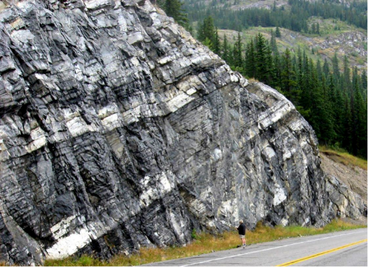
Bedding, for example, is the separation of sediments into layers that either differ from one another in textures, composition, colour, or weathering characteristics, or are separated by partings —narrow gaps between adjacent beds (Figure 6.4.1). Bedding is an indication of changes in depositional processes that may be related to seasonal differences, changes in climate, changes in locations of rivers or deltas, or tectonic changes. Partings may represent periods of non-deposition that could range from a few decades to a few millennia. Bedding can form in almost any sedimentary depositional environment.
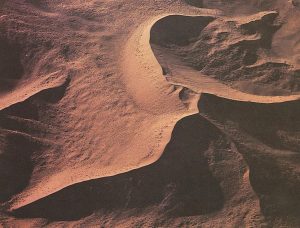
Cross-bedding is bedding that contains angled layers within otherwise horizontal beds, and it forms when sediments are deposited by flowing water or wind. Some examples are shown in Figures 6.0.11, 6.1.7b, and 6.4.2. Cross-beds formed in streams tend to be on the scale of centimetres to tens of centimetres, while those in aeolian (wind deposited) sediments can be on the scale of metres to several metres.
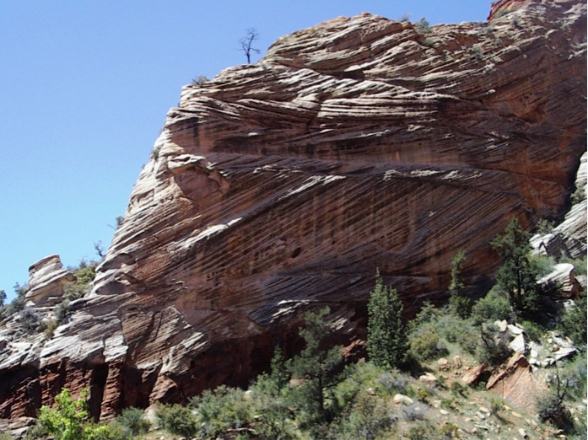
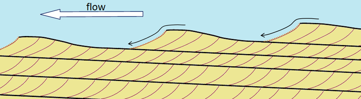
Cross-beds form as sediments are deposited on the leading edge of an advancing ripple or dune under steady state conditions (similar flow rate and same flow direction). Each layer is related to a different ripple that advances in the direction of flow, and is partially eroded by the following ripple (Figure 6.4.3). Cross-bedding is a very important sedimentary structure to be able to recognize because it can provide information on the process of deposition, the direction of current flows and, when analyzed in detail, on other features like the rate of flow and the amount of sediment available.
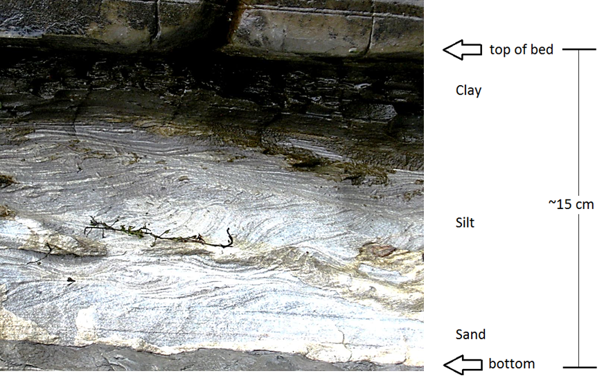
Graded bedding is characterized by a gradation in grain size from bottom to top within a single bed. “Normal” graded beds are coarse at the bottom and become finer toward the top. They are a product of deposition from a slowing current (Figure 6.4.4). Most graded beds form in a submarine-fan environment (see Figure 6.4.1), where sediment-rich flows descend periodically from a shallow marine shelf down a slope and onto the deeper sea floor. Some graded beds are reversed (coarser at the top), and this normally results from deposition by a fast-moving debris flow (see Chapter 15).
Ripples, which are associated with the formation of cross-bedding, may be preserved on the surfaces of sedimentary beds. Ripples can also help to determine flow direction as they tend to have their steepest surface facing in the direction of the flow (see Figure 6.4.3).
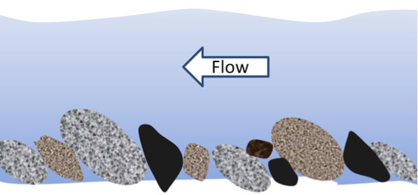
In a stream environment, boulders, cobbles, and pebbles can become imbricated, meaning that they are generally tilted in the same direction. Clasts in streams tend to tilt with their upper ends pointing downstream because this is the most stable position with respect to the stream flow (Figure 6.4.5 and Figure 6.1.7c).
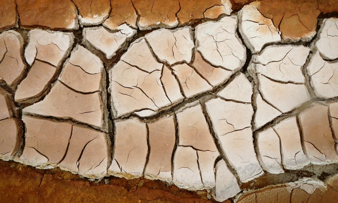
Mud cracks form when a shallow body of water (e.g., a tidal flat or pond or even a puddle), into which muddy sediments have been deposited, dries up and cracks (Figure 6.4.6). This happens because the clay in the upper mud layer tends to shrink on drying, and so it cracks because it occupies less space when it is dry.
The various structures described above are critical to understanding and interpreting the conditions that existed during the formation of sedimentary rocks. We’ll be using this information to explain formations we see in U.S. National Parks today.
Attributions:
Modified from: Physical Geology – 2nd Edition by Steven Earle is used under a Creative Commons Attribution 4.0 International Licence. Download for free from the B.C. Open Collection.
Modified from: Johnson, Chris , et al. An Introduction to Geology. Salt Lake Community College, 2017, opengeology.org/textbook/. (Licensed under a Creative Commons Attribution-NonCommercial-ShareAlike 4.0 International License.)
Figure 5.1.1 by Steven Earle, CC BY 4.0
Figure 5.1.2 by Steven Earle, CC BY 4.0
Figure 5.1.3 by Steven Earle, CC BY 4.0
Figure 5.1.4 by Steven Earle, CC BY 4.0
Figure 5.2.1 by Steven Earle, CC BY 4.0
Figure 5.2.2 by Steven Earle, CC BY 4.0
Figure 5.2.4 by Steven Earle, CC BY 4.0
Figure 6.3.1 Schematic diagram showing types of depositional environment © Mike Norton. Adapted by Steven Earle. CC BY-SA.
Figure 13.3.1 by Steven Earle, CC BY 4.0
Figure 13.3.2 by Steven Earle, CC BY 4.0
Figure 13.3.4 by Steven Earle, CC BY 4.0
Figure 6.4.1 by Steven Earle, CC BY 4.0
Figure 6.4.2 by Steven Earle, CC BY 4.0
Figure 6.4.3 by Steven Earle, CC BY 4.0
Figure 6.4.4 by Steven Earle, CC BY 4.0
Figure 6.4.5 by Steven Earle, CC BY 4.0
Figure 6.4.6 by Steven Earle, CC BY 4.0
Figure 6.4.7 by Steven Earle, CC BY 4.0
