5 Glaciers!
How Glaciers Work
There are two main types of glaciers.
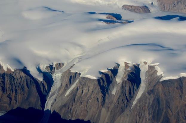
Continental glaciers cover vast areas of land in extreme polar regions, including Antarctica and Greenland (Figure 16.2.1).
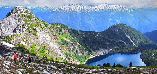
Alpine glaciers (a.k.a. valley glaciers) originate on mountains, mostly in temperate and polar regions (Figure 16.0.1), but even in tropical regions if the mountains are high enough.
Earth’s two great continental glaciers, on Antarctica and Greenland, comprise about 99% of all of the world’s glacial ice, and approximately 68% of all of Earth’s fresh water. The Antarctic Ice Sheet is vastly bigger than the Greenland Ice Sheet; it contains about 17 times as much ice. If the entire Antarctic Ice Sheet were to melt, sea level would rise by about 80 m and most of Earth’s major cities would be completely submerged.
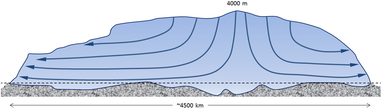
Continental glaciers do not flow “downhill” because the large areas that they cover are generally flat. Instead, ice flows from the region where it is thickest toward the edges where it is thinner, as shown in Figure 16.2.3. This means that in the central thickest parts, the ice flows almost vertically down toward the base, while in the peripheral parts, it flows out toward the margins. In continental glaciers like Antarctica and Greenland, the thickest parts (4,000 m and 3,000 m respectively) are the areas where the rate of snowfall and therefore the rate of ice accumulation are highest.
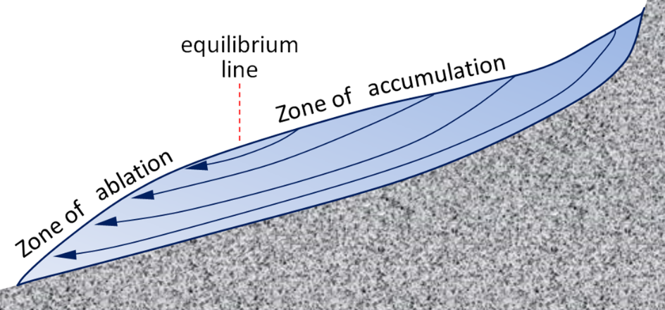
The flow of alpine glaciers is primarily controlled by the slope of the land beneath the ice (Figure 16.2.4). In the zone of accumulation, the rate of snowfall is greater than the rate of melting. In other words, not all of the snow that falls each winter melts during the following summer, and the ice surface is always covered with snow. In the zone of ablation, more ice melts than accumulates as snow. The equilibrium line marks the boundary between the zones of accumulation (above) and ablation (below).
Above the equilibrium line of a glacier, not all of the winter snow melts in the following summer, so snow gradually accumulates. The snow layer from each year is covered and compacted by subsequent snow, and it is gradually compressed and turned into firn within which the snowflakes lose their delicate shapes and become granules. With more compression, the granules are pushed together and air is squeezed out. Eventually the granules are “welded” together to create glacial ice (Figure 16.2.5). Downward percolation of water from melting taking place at the surface contributes to the process of ice formation.
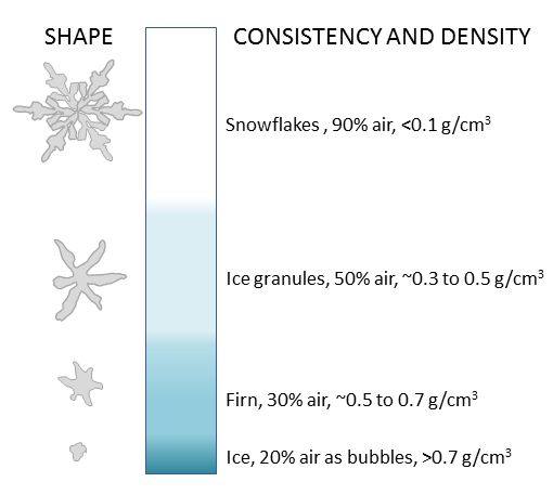
Figure 16.2.5 image description: The comparative density of snowflakes, ice granules, firn, and ice.
|
Shape |
Amount of air |
Density (grams per centimetres cubed) |
|---|---|---|
|
Snowflake |
90% |
Less than 0.1 |
|
Ice Granules |
50% |
From around 0.3 to 0.5 |
|
Firn |
30% |
From around 0.5 to 0.7 |
|
Ice |
20% (as bubbles) |
Greater than 0.7 |
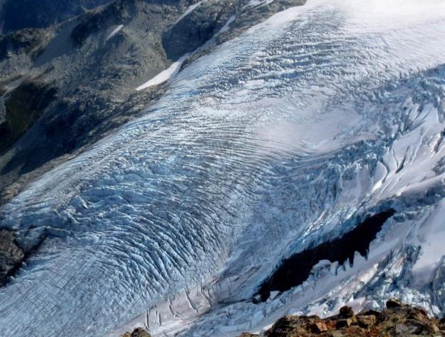
The equilibrium line of a glacier near Whistler, B.C., is shown in Figure 16.2.6. Below that line, in the zone of ablation, bare ice is exposed because last winter’s snow has all melted; above that line, the ice is still mostly covered with snow from last winter. The position of the equilibrium line changes from year to year as a function of the balance between snow accumulation in the winter and snowmelt during the summer. More winter snow and less summer melting obviously favours the advance of the equilibrium line (and of the glacier’s leading edge), but of these two variables, it is the summer melt that matters most to a glacier’s budget. Cool summers promote glacial advance and warm summers promote glacial retreat.
Glaciers move because the surface of the ice is sloped. This generates a stress on the ice, which is proportional to the slope and to the depth below the surface. The stresses are quite small near the ice surface but much larger at depth, and also greater in areas where the ice surface is relatively steep. Ice will deform, meaning that it will behave in a plastic manner, at stress levels of around 100 kilopascals; therefore, in the upper 50 m to 100 m of the ice (above the dashed red line), flow is not plastic (the ice is rigid), while below that depth, ice is plastic and will flow.
When the lower areas of ice of a glacier flows, it moves the upper ice along with it, so although it might seem from the stress that the part underneath moves the most; in fact while the lower part deforms (and flows) and the upper part doesn’t deform at all; the upper part moves the fastest because it is pushed along by the ice below it.
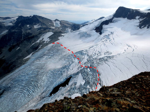
The plastic lower ice of a glacier can flow like a very viscous fluid, and can therefore flow over irregularities in the base of the ice and around corners. However, the upper rigid ice cannot flow in this way, and because it is being carried along by the lower ice, it tends to crack where the lower ice has to flex. This leads to the development of crevasses in areas where the rate of flow of the plastic ice is changing. In the area shown in Figure 16.2.8, for example, the glacier is speeding up over the steep terrain, and the rigid surface ice has to crack to account for the change in velocity.
The base of a glacier can be cold (below the freezing point of water) or warm (above the freezing point). If it is warm, there will likely be a film of water between the ice and the material underneath, and the ice will be able to slide over that surface. This is known as basal sliding. If the base is cold, the ice will be frozen to the material underneath and it will be stuck—unable to slide along its base. In this case, all of the movement of the ice will be by internal flow.
One of the factors that affects the temperature at the base of a glacier is the thickness of the ice. Ice is a good insulator. The slow transfer of heat from Earth’s interior provides enough heat to warm up the base if the ice is thick, but not enough if it is thin and that heat can escape. It is typical for the leading edge of an alpine glacier to be relatively thin.
Just as the base of a glacier moves more slowly than the surface, the edges, which are more affected by friction along the sides, move more slowly than the middle.
Glacial ice always moves downhill, in response to gravity, but the front edge of a glacier is always either melting or calving into water (shedding icebergs). If the rate of forward motion of the glacier is faster than the rate of ablation (melting), the leading edge of the glacier advances (moves forward). If the rate of forward motion is about the same as the rate of ablation, the leading edge remains stationary, and if the rate of forward motion is slower than the rate of ablation, the leading edge retreats (moves backward).
Calving of icebergs is an important process for glaciers that terminate in lakes or the ocean.
Glacial Erosion
Glaciers are effective agents of erosion, especially in situations where the ice is not frozen to its base and can therefore slide over the bedrock or other sediment. In fact, the ice itself is not particularly effective at erosion because it is relatively soft (Mohs hardness 1.5 at 0°C); instead, it is the rock fragments embedded in the ice and pushed down onto the underlying surfaces that do most of the erosion. A useful analogy would be to compare the effect of a piece of paper being rubbed against a wooden surface, as opposed to a piece of sandpaper that has embedded angular fragments of garnet.
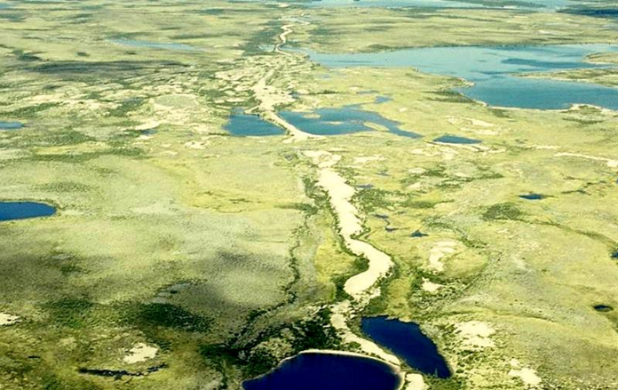
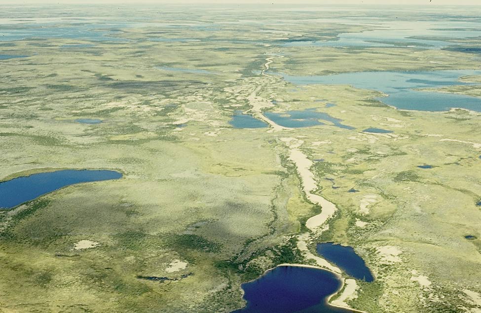
The results of glacial erosion are different in areas with continental glaciation versus alpine glaciation. Continental glaciation tends to produce relatively flat bedrock surfaces, especially where the rock beneath is uniform in strength. In areas where there are differences in the strength of rocks, a glacier obviously tends to erode the softer and weaker rock more effectively than the harder and stronger rock. In many cases the existing relief is due the presence of glacial deposits—such as drumlins, eskers, and moraines (all discussed below)—rather than to differential erosion (Figure 16.3.1).
Alpine glaciers produce very different topography than continental glaciers, and much of the topographic variability of western Canada can be attributed to glacial erosion. In general, glaciers are much wider than rivers of similar length, and since they tend to erode more at their bases than their sides, they produce wide valleys with relatively flat bottoms and steep sides—known as U-shaped valleys (Figure 16.3.2).
U-shaped valleys and their tributaries provide the basis for a wide range of alpine glacial topographic features, examples of which are visible on the International Space Station view of the Swiss Alps shown in Figure 16.3.4. This area was much more intensely glaciated during the past glacial maximum. At that time, the large U-shaped valley in the lower right was occupied by glacial ice, and all of the other glaciers shown here were longer and much thicker than they are now. But even at the peak of the Pleistocene Glaciation, some of the higher peaks and ridges would have been exposed and not directly affected by glacial erosion. A peak that extends above the surrounding glacier is called a nunatuk. In these areas, and in the areas above the glaciers today, most of the erosion is related to freeze-thaw effects.
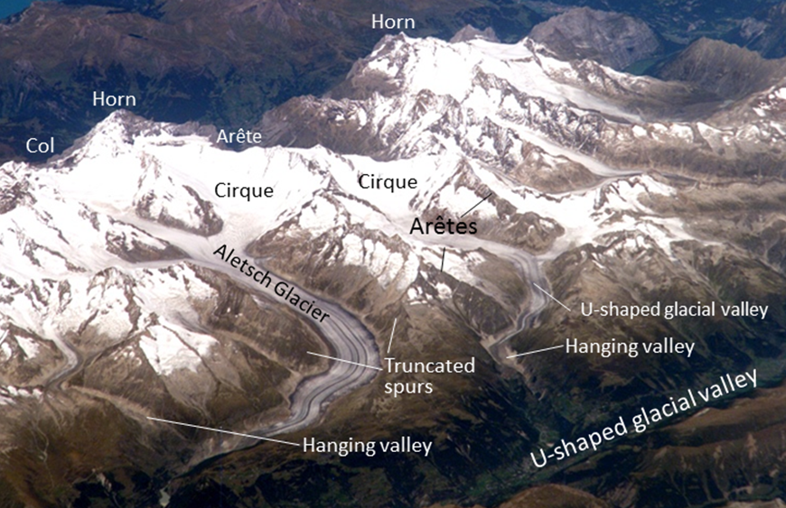
Figure 16.3.4 is a Space Station view of a glaciated terrain in the Swiss Alps. Some of the important features visible are
- arêtes: sharp ridges between U-shaped glacial valleys;
- cols: low points along arêtes that constitute passes between glacial valleys;
- horns: steep peaks that have been glacially and freeze-thaw eroded on three or more sides;
- cirques: bowl-shaped basins that form at the head of a glacial valley;
- hanging valleys: U-shaped valleys of tributary glaciers that hang above the main valley because the larger main-valley glacier eroded more deeply into the terrain; and
- truncated spurs(a.k.a. “spurs”): the ends of arêtes that have been eroded into steep triangle-shaped cliffs by the glacier in the corresponding main valley.
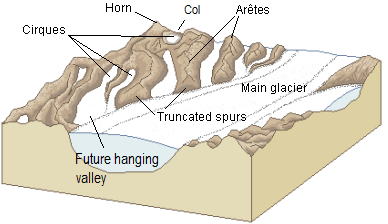
Some of these alpine-glaciation erosional features are also shown in Figure 16.3.5 in diagram form.
A number of other glacial erosion features exist at smaller scales. For example, a drumlinis an elongated feature that is streamlined at the down-ice end. The one shown in Figure 16.3.7 is larger than most, and is made up almost entirely of rock. Drumlins made up of glacial sediments are very common in some areas of continental glaciation (Figure 16.3.1).
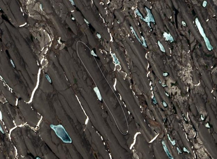
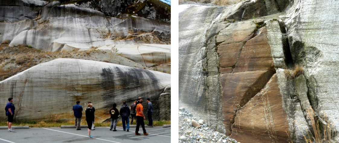
A roche moutonnée is another type of elongated erosional feature that has a steep and sometimes jagged down-ice end (Figure 16.3.8, left). On a smaller scale still, glacial grooves (tens of centimetres to metres wide) and glacial striation (millimetres to centimetres wide) are created by fragments of rock embedded in the ice at the base of a glacier (Figure 16.3.8, left and right). Glacial striae are very common on rock surfaces eroded by both alpine and continental glaciers.
Glacial lakes
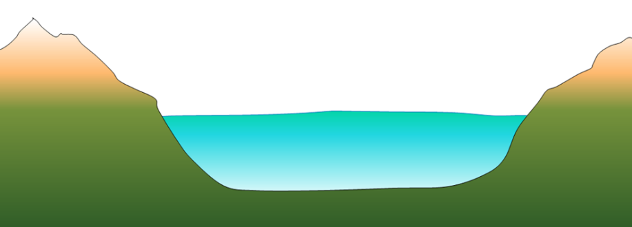
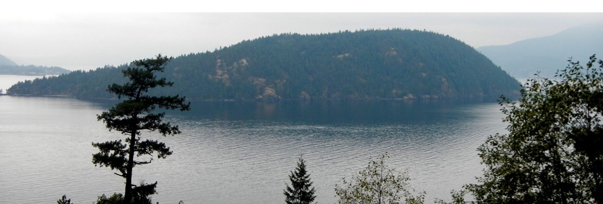
Lakes are common features in glacial environments. A lake that is confined to a glacial cirque is known as a tarn (Figure 16.3.9). Tarns are common in areas of alpine glaciation because the ice that forms a cirque typically carves out a depression in bedrock that then fills with water. In some cases, a series of such basins will form, and the resulting lakes are called or rock basin lakes or paternoster lakes.
A lake that occupies a glacial valley, but is not confined to a cirque, is known as a finger lake. In some cases, a finger lake is confined by a dam formed by an end moraine, in which case it may be called a moraine lake (Figure 16.3.10).

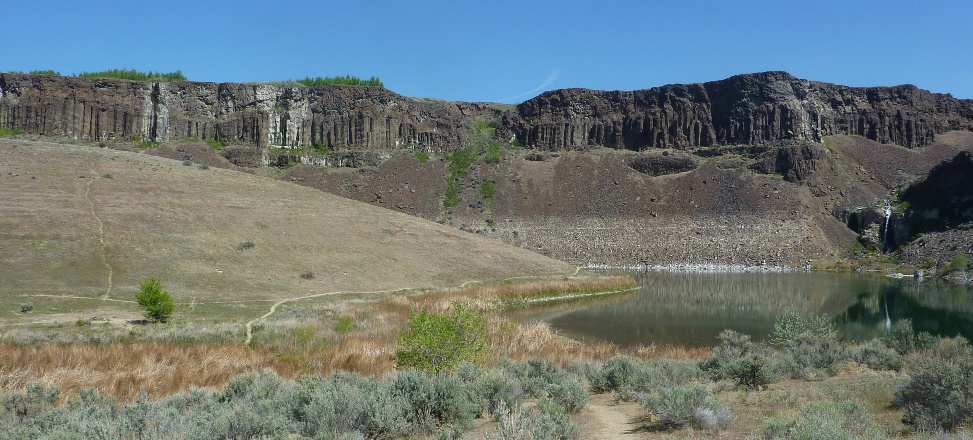
In areas of continental glaciation, the crust is depressed by the weight of glacial ice that is up to 4,000 m thick. Basins are formed along the edges of continental glaciers (except for those that cover entire continents like Antarctica and Greenland), and these basins fill with glacial meltwater. Many such lakes, some of them huge, existed at various times along the southern edge of the Laurentide Ice Sheet. One example is Glacial Lake Missoula, which formed within Idaho and Montana in northwestern United States. During the latter part of the last glaciation (30 ka to 15 ka), the ice holding back Lake Missoula retreated enough to allow some of the lake water to start flowing out, which escalated into a massive and rapid outflow (over days to weeks) during which much of the volume of the lake drained along the valley of the Columbia River to the Pacific Ocean. It is estimated that this type of flooding happened at least 25 times over that period, and in many cases, the rate of outflow was equivalent to the discharge of all of Earth’s current rivers combined. The record of these massive floods is preserved in the Channelled Scablands of Idaho, Washington, and Oregon (Figure 16.3.11).
Another type of glacial lake is a kettle lake. These are discussed later in the context of glacial deposits.
Glacial Deposition
Sediments transported and deposited during the Pleistocene glaciations are abundant throughout Canada and much of the northern USA. They are important sources of construction materials and are valuable as reservoirs for groundwater. Because they are almost all unconsolidated, they have significant implications for mass wasting.
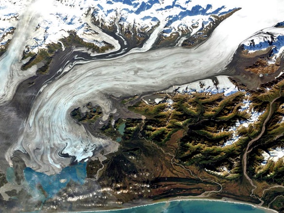
Figure 16.4.1 illustrates some of the ways that sediments are transported and deposited. The Bering Glacier is the largest in North America, and although most of it is in Alaska, it flows from an icefield that extends into southwestern Yukon. The surface of the ice is partially, or in some cases completely covered with rocky debris that has fallen from surrounding steep rock faces. There are muddy rivers issuing from the glacier in several locations, depositing sediment on land, into Vitus Lake, and directly into the ocean. There are dirty icebergs shedding their sediment into the lake. And, not visible in this view, there are sediments being moved along beneath the ice.
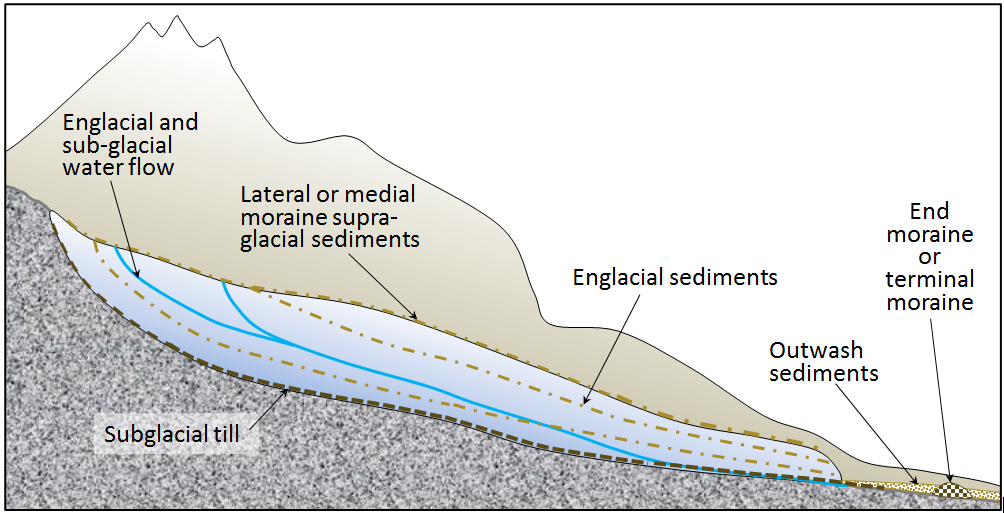
The formation and movement of sediments in glacial environments is shown diagrammatically in Figure 16.4.2. There are many types of glacial sediment generally classified by whether they are transported on, within, or beneath the glacial ice. The main types of sediment in a glacial environment are described below.
Supraglacial (on top of the ice) and englacial (within the ice) sediments that slide off the melting front of a stationary glacier can form a ridge of unsorted sediments called a terminal moraine. The end moraine that represents the farthest advance of the glacier is an end moraine. Supraglacial and englacial sediments can also be deposited when the ice melts. Sediments transported and deposited by glacial ice are known as till.
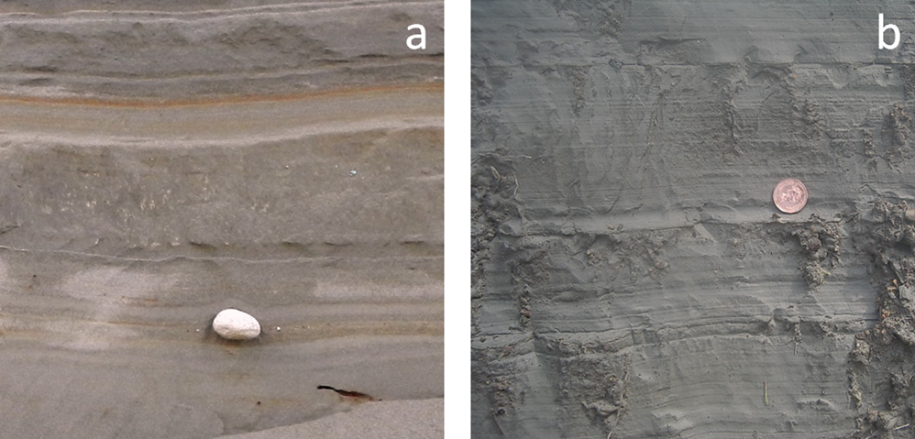
Subglacial sediment is material that has been eroded from the underlying rock by the ice, and is moved by the ice. It has a wide range of grain sizes (in other words it is poorly sorted), including a relatively high proportion of silt and clay. The larger clasts (pebbles to boulders in size) tend to become partly rounded by abrasion. Lodgement till forms as a sheet of well-compacted sediment beneath a glacier, and ranges from several centimetres to many metres in thickness. Lodgement till is normally unbedded. An example is shown in Figure 16.4.3a.
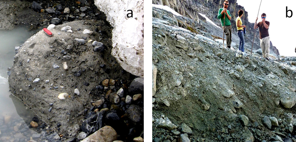
Supraglacial sediments are primarily derived from freeze-thaw eroded material that has fallen onto the ice from rocky slopes above. These sediments form lateral moraines (Figure 16.0.1) and, where two glaciers meet, medial moraines. (Medial moraines are visible on the Aletsch Glacier in Figure 16.3.4.) Most of this material is deposited on the ground when the ice melts, and is therefore called ablation till, a mixture of fine and coarse angular rock fragments, with much less sand, silt, and clay than lodgement till. An example is shown in Figure 16.4.3b. When supraglacial sediments become incorporated into the body of the glacier, they are known as englacial sediments (Figure 16.4.2).
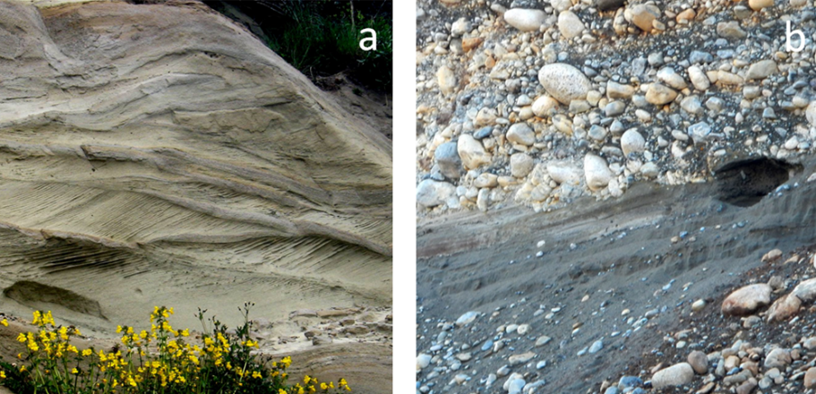
Massive amounts of water flow on the surface, within, and at the base of a glacier, even in cold areas and even when the glacier is advancing. Depending on its velocity, this water is able to move sediments of various sizes and most of that material is washed out of the lower end of the glacier and deposited as outwash sediments. These sediments accumulate in a wide range of environments in the proglacial region (the area in front of a glacier), most in fluvial environments, but some in lakes and the ocean. Glaciofluvial sediments are similar to sediments deposited in normal fluvial environments, and are dominated by silt, sand, and gravel. The grains tend to be moderately well rounded, and the sediments have similar sedimentary structures (e.g., bedding, cross-bedding, clast imbrication) to those formed by non-glacial streams (Figure 16.4.4a and 16.4.4b).
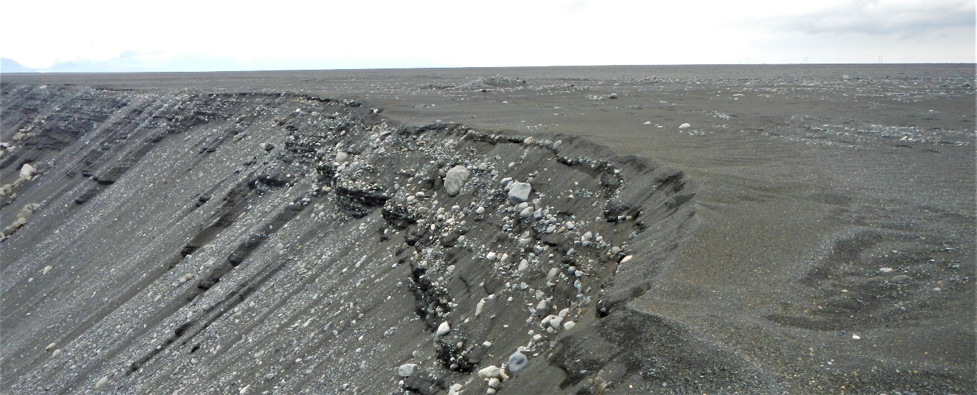
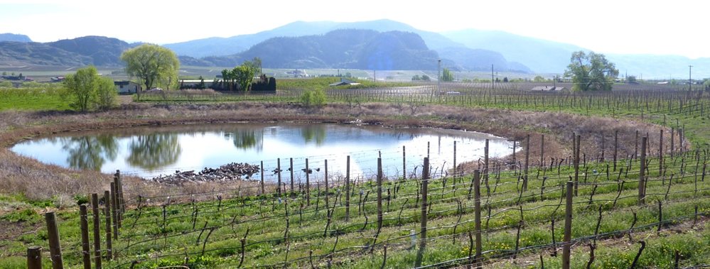
A large proglacial plain of sediment is called a sandur (a.k.a. an outwash plain), and within that area, glaciofluvial deposits can be tens of metres thick (Figure 16.4.5). In situations where a glacier is receding, a block of ice might become separated from the main ice sheet and then get buried in glaciofluvial sediments. When the ice block eventually melts, a depression forms, known as a kettle, and if this fills with water, it is known as a kettle lake (Figure 16.4.6).
A subglacial stream will create its own channel within the ice, and sediments that are being transported and deposited by the stream will build up within that channel. When the ice recedes, the sediment will remain to form a long sinuous ridge known as an esker. Eskers are most common in areas of continental glaciation. They can be several metres high, tens of metres wide, and tens of kilometres long (Figure 16.4.7).
Outwash streams commonly flow into proglacial lakes where glaciolacustrine sediments are deposited. These are dominated by silt- and clay-sized particles and are typically laminated on the millimetre scale. In some cases, develop; varves are series of beds with distinctive summer and winter layers: relatively coarse in the summer when melt discharge is high, and finer in the winter, when discharge is very low. Icebergs are common on proglacial lakes, and most of them contain englacial sediments of various sizes. As the bergs melt, the released clasts sink to the bottom and are incorporated into the glaciolacustrine layers as drop stones (Figure 16.4.8a).
The processes that occur in proglacial lakes can also take place where a glacier terminates at the ocean. The sediments deposited there are called glaciomarine sediments (Figure 16.4.8b).
Attributions:
Modified from: Physical Geology – 2nd Edition by Steven Earle is used under a Creative Commons Attribution 4.0 International Licence. Download for free from the B.C. Open Collection.
Figure 16.4.1: “Bering Glacier” by NASA Earth Observatory. Public domain.
Figure 16.4.2 by Steven Earle, CC BY 4.0
Figure 16.4.3 by Steven Earle, CC BY 4.0
Figure 16.4.4 by Steven Earle, CC BY 4.0
Figure 16.4.5 by Steven Earle, CC BY 4.0
Figure 16.4.6 by Steven Earle, CC BY 4.0
Figure 16.4.8 by Steven Earle, CC BY 4.0
Figure 16.4.7 “Esker on a morainal plain” © Canadian Soil Information Service (CANSIS). Approved for non-commercial reproduction.
Figure 16.2.1 by Steven Earle, CC BY 4.0
Figure 16.2.3 by Steven Earle, CC BY 4.0
Figure 16.2.6 “Overlord Glacier” by Isaac Earle. Adapted by Steven Earle. CC BY 4.0
Figure 16.2.8 “Crevasses at Overlord Glacier” by Isaac Earle. CC BY 4.0
Figure 16.3.1 by Steven Earle, CC BY 4.0
Figure 16.3.2 “Drumlin Field in Northern Canada” by NASA Earth Observatory. Public domain.
Figure 16.3.4 “Bernese Alps, Switzerland” by NASA Earth Observatory. Adapted by Steven Earle. Public domain.
Figure 16.3.5 “Glacial landscape LMB” by Luis María Benítez. Public domain.
Figure 16.3.7 by Steven Earle, CC BY 4.0
Figure 16.3.8 by Steven Earle, CC BY 4.0
Figure 16.3.9 “Trappers Peak and lower Thorton Lake” © X-Weinzar. CC BY
Figure 16.3.10 “Peyto Lake Panorama 2006” © chensiyuan. CC BY-SA
Figure 16.3.11 by Steven Earle, CC BY 4.0
