Rocks and Plate Tectonics
Rocks and Plate Tectonics Lab
Purpose and Objectives:
- To receive hands-on experience with identifying basic minerals, igneous rocks, sedimentary rocks, and metamorphic rocks using a variety of tools.
- To recognize the names and locations of Earth’s main plates.
- To recognize plate boundary types, based on their location and relative plate movements, and to connect those to environmental conditions.
Introduction:
The Theory of Plate Tectonics is the grand, unifying theory of geology that explains the distribution of major features such as mountain belts, earthquakes, volcanoes, rock types and much more. To understand plate tectonics, one must have an understanding of Earth’s layers with two different perspectives: layers based on chemistry and those based on physical properties (listed below). Figure 1 below highlights both types of layering side-by-side.
- Earth’s chemical layers: crust (continental and oceanic types), mantle, core.
- Earth’s physical layers: lithosphere, asthenosphere, outer core, inner core.
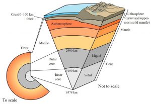
Figure 1: The chemical & physical layers of the Earth with approximate thicknesses (United States Geological Survey Public Domain).
The continental crust is thick and lower in density. It has an average composition of felsic-intermediate igneous rocks (you’ll learn more about these terms in part 3 of this lab). For now, one can think of felsic as “light-colored rocks.” The oceanic crust is think and higher in density. It has an average composition of mafic igneous rocks (think “dark-colored rocks”). In other words, one can think of continental crust as like cork, and the oceanic crust being like sheet metal. The mantle is the thickest chemical layer, and has an ultramafic average igneous composition (“ultra-dark rocks”). The core is widely-believed to be a nickel-iron alloy.
For our studying of plate tectonics, Earth’s physical layers take center stage. The lithosphere comprises the entire crust as well as the uppermost part of the mantle. Although the crust and mantle are different chemical compositions, these two parts are unified as the lithosphere due to their brittle nature. This thin, hard layer is like an eggshell or a cracker. It is the lithosphere that is more colloquially known as our “plates!” The rest of the mantle, in between the lithosphere and the core is the asthenosphere. It is a hot solid that is slowly flowing (like a hot plastic or wax). It is this flowy nature that mechanically moves the plates above it, like a conveyor belt (Figure 2). Lastly, the outer core is liquid metal (iron-nickel alloy, as mentioned above), whereas the inner core is solid metal alloy.
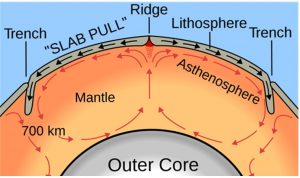
Figure 2: Earth’s physical layers in the context of plate motion and how asthenosphere convection moves the plates above (United States Geological Survey Public Domain).
The Earth is broken up into 15 major plates, with many more minor plates (microplates). With all plates being in some sort of motion, and with two different types of crust (continental & oceanic), there are multiple combinations in which plates interact & move relative to one another.
One broad plate boundary is convergent, where any two plates collide with each other. During a continental-oceanic convergence, the oceanic crust subducts due to its greater density. Since the oceanic crust is hydrated, water locked up in minerals “boils off” after reaching a certain depth, which is directly related to temperature. The water acts like a flux which makes the overlying mantle rocks easier to melt. Since (most) liquids are less dense than their solid counterparts, the melt begins to ascend towards the surface. The melt may or may not reach the surface to produce volcanism. Oceanic-oceanic convergence operates in the same manner, with the older (thus denser & colder) of the pair subducting & generating melt in the same fashion. Convergence between two thick continental plates causes crustal thickening as no subduction takes place. This results in the formation of non-volcanic mountain belts (i.e. the Himalayas).
Divergent plate boundaries are where two plates spread away from each other. The most common occurrence is between two oceanic plates along a spreading center. Here, hot asthenosphere material quickly rises from under the center, loses pressure, & melts via decompression melting. The erupted lava pushes the plates apart, while forming new land in its place. The same thing can happen on a continent, but its mechanisms are more complex.
Transform plate boundaries are those where two plates slide past each other. Here, there is no destruction nor creation of land. Hence, this is the only plate boundary where no magma is generated. In rarer cases volcanism can occur in the middle of any type of plate, via a hot spot, or a plume of anomalously hot material originated from the deep mantle (with melting occurring due to a simple increase in heat). An oceanic example is the Hawaiian Islands, and a continental example resides underneath Yellowstone National Park, Wyoming. Hot spots can be used to trace plate velocity and direction over time, by dating the produced igneous rocks, the distance between them, as well as knowing that hot spots remain stationary.
Part 1 – Plate Tectonics & Earthquakes
Directions:
- Click on the following link to pull up a world map using an ArcGIS program (Cracked Earth – Plate Boundaries Interactive Map).
- To start, make sure only the “Plate Boundaries” box is checked. Then visit the “Legend” tab to see what the different color lines represent.
Question #1: Approximate what proportion of the world’s plate boundaries are of the following types (give your answer as percentages):
- Convergent –
- Divergent –
- Transform –
Question #2: Now focus on the “Ring of Fire that surrounds the Pacific Ocean. Approximate what proportion of each plate boundary type exists there (again, give percentages):
- Convergent –
- Divergent –
- Transform –
Question #3: Now, go to the “Layers” tab and check the box “Global Quakes of Large Magnitude 5.8 or Greater.” What do you notice about where most of these quakes occur?
Question #4: Now, check the “California Quakes” box. What do you notice?
- Zoom back out to get a world map view. You can do this by clicking on the box with a house (Default Extent). Next, check the “Absolute Plate Motions” box. You’ll see a variety of arrows with numbers appear. These show plate directions and average speed a year (in millimeters). The arrows are like vectors. The longer the arrow, the faster the plate is moving.
Question #5: Which plate is moving the slowest? The fastest? For both answers, give the speed and directions.
- Now, we’ll get some experience in using the measuring tool (found along the top of the map).
Question #6: Remaining in California, measure the approximate length of the San Andreas Fault complex (Hint: it’s a transform fault). Make sure to report your measurement in either miles or kilometers.
Question #7: In continuing further south in the Gulf of California, you’ll notice the start of a divergent boundary. It is widely believed that the Baja Peninsula (immediately to the west) was once part of mainland Mexico (to the east). Using the nearest appropriate absolute plate motion (of the Pacific Ocean), as well as the measurement tool, calculate approximately how many years ago was the Baja Peninsula was connected to the Mexico mainland?
- Next, head to the west coastline of South America, and check the box “South American Quakes” (make sure the “Plate Boundaries” box is also checked). In hovering around that option, you’ll see some additional symbols appear. Click on the “Change Style” option (the one represented by the three shapes). With the “Choose an Attribute to Show” option that pops up, select “Depth” then hit the blue “Done” button.
Question #8: In relation to the plate boundary, where are the deepest earthquakes located? What about the shallowest quakes?
Question #9: In knowing what happens, in terms of the process of subduction, at this type of plate boundary, explain why the earthquake depth pattern is the way it is. In other words, explain your answers from question #8.
Question #10: Zoom out so the world is in view. Next, visit the following places below and complete the table.
Wrap-Up Questions:
- Haiti
- Intraplate earthquakes
- Connect EQ with ENV science
Part 2 – Plate Tectonics & Volcanoes
Directions:
- For this portion, you’ll be exploring a different interactive map (Plate Type Effect on Volcanoes).
- On the left side of the map, click “Layers” tab. Check the “Plate Boundaries” box. Hover underneath that box and click on the “Show Legend” icon.
- Check the “Global Volcanoes” box. Hover underneath that box and click on the “Show Legend” icon.
Question #1: Which type of plate boundary has the most volcanoes?
- Next, go to California.
Question #2: Where do you see volcanoes in the state? With what type of plate boundary do you not see volcanoes associated with?
Question #3: With what type of plate boundary, in California, do you not see volcanoes associated with?
- Next, go to Hawaii.
Question #4: What type of volcano is Hawaii dominantly composed of? Is Hawaii associated with a plate boundary? How can this be explained?
- Now, zoom back out to see the Earth.
Question #5: Note all the potential hotspots that you see on Earth. Approximately what proportion of the world’s hotspots are in the ocean versus on continents? Give your answer with percentages.
Question #6: What volcano type do you notice most of the world’s continental hot spots are?
Wrap-Up Questions:
- What plate boundary types are not associated with volcanoes? Briefly explain why these boundaries are not conducive to volcano formation.
- Two of the most common volcano types are shield & fissure volcanoes as well as composite volcanoes. They erupt with very different behaviors. Hence, they present different environmental hazards. Briefly explain how each volcano type (with the main hazard listed) can specifically alter their surrounding ecosystems.
- Shield/Fissure, like in Hawaii (main hazard are slow-moving lava flows) –
- Composite, like in the Pacific Northwest (main hazard is ash) –
Part 3 – Practice with Rock & Mineral Identification!
Directions:
- For this portion, you’ll be given a suite of minerals, igneous rocks, sedimentary rocks and metamorphic rocks, as well as identification tables and tools to guide you in the identification process.
- Identify all the provided specimens as best as you can!