37 4.4 Volcanic Hazards — Physical Geology – 2nd Edition
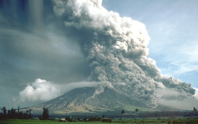
Pyroclastic Fall
Most of the tephra from an explosive eruption ascends high into the atmosphere, and some of it is distributed around Earth by high-altitude winds. The larger components (larger than 0.1 mm) tend to fall relatively close to the volcano, and the amount produced by large eruptions can cause serious damage and casualties. The large 1991 eruption of Mount Pinatubo in the Philippines resulted in the accumulation of tens of centimetres of ash in fields and on rooftops in the surrounding populated region. Heavy typhoon rains that hit the island at the same time added to the weight of the tephra, leading to the collapse of thousands of roofs and to at least 300 of the 700 deaths attributed to the eruption.
Lahar
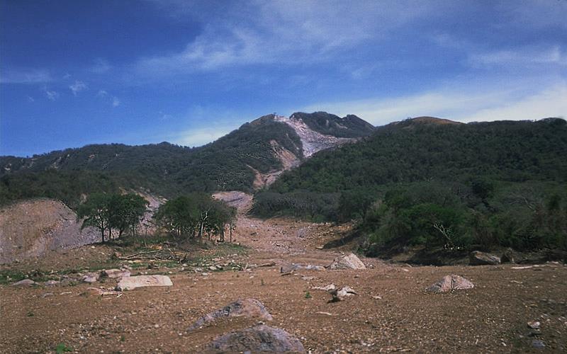
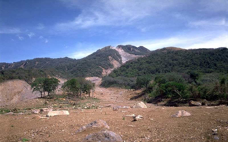
A lahar is any mudflow or debris flow that is related to a volcano. Most are caused by melting snow and ice during an eruption, as was the case with the lahar that destroyed the Colombian town of Armero in 1985 (described earlier). Lahars can also happen when there is no volcanic eruption, and one of the reasons is that, as we’ve seen, composite volcanoes tend to be weak and easily eroded.
In October 1998, category 5 hurricane Mitch slammed into the coast of central America. Damage was extensive and 19,000 people died, not so much because of high winds but because of intense rainfall—some regions received almost 2 m of rain over a few days! Mudflows and debris flows occurred in many areas, especially in Honduras and Nicaragua. An example is at the Casita Volcano in Nicaragua, where the heavy rains weakened rock and volcanic debris on the upper slopes, resulting in a debris flow that rapidly built in volume as it raced down the steep slope, and then ripped through the towns of El Porvenir and Rolando Rodriguez killing more than 2,000 people (Figure 4.4.2). El Porvenir and Rolando Rodriguez were new towns that had been built without planning approval in an area that was known to be at risk of lahars.
Sector Collapse and Debris Avalanche
In the context of volcanoes, sector collapse or flank collapse is the catastrophic failure of a significant part of an existing volcano, creating a large debris avalanche. This hazard was first recognized with the failure of the north side of Mount St. Helens immediately prior to the large eruption on May 18, 1980. In the weeks before the eruption a large bulge had formed on the side of the volcano, the result of magma transfer from depth into a satellite magma body within the mountain itself. Early on the morning of May 18, a moderate earthquake struck nearby; this is thought to have destabilized the bulge, leading to Earth’s largest ever observed slope failure. The failure of this part of the volcano exposed the underlying satellite magma chamber, causing it to explode sideways, which then exposed the conduit leading to the magma chamber below. The resulting plinian eruption—with a 24 kilometre high eruption column—lasted for nine hours.
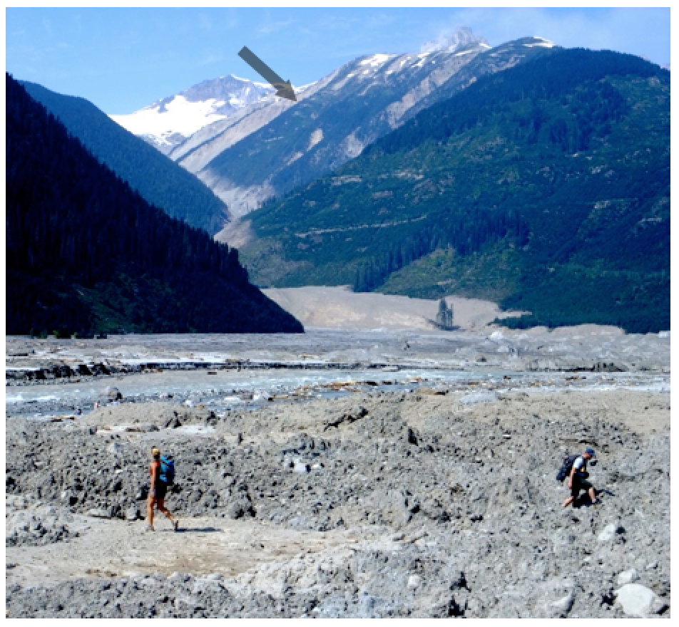
In August 2010, a massive part of the flank of B.C.’s Mount Meager gave way and about 48 million cubic metres (m3) of rock rushed down the valley, one of the largest slope failures in Canada in historical times (Figure 4.4.3). More than 25 slope failures have taken place at Mount Meager in the past 8,000 years, some of them more than 10 times larger than the 2010 failure.
Lava Flows
As we saw in Exercise 4.4, lava flows at volcanoes like Kilauea do not advance very quickly, and in most cases, people can get out of the way. Of course, it is more difficult to move infrastructure, and so buildings and roads are typically the main casualties of lava flows.
The town of Squamish is situated approximately 10 km from Mount Garibaldi, as shown in the photo. If Mount Garibaldi were to erupt, which of the following hazards could be an issue for people in and around Squamish? Explain why or why not.
- Tephra emission.
- Gas emission.
- Pyroclastic denisty current.
- Pyroclastic fall.
- Lahar.
- Sector collapse.
- Lava flow.
See Appendix 3 for Exercise 4.5 answers.
Media Attributions
- Figure 4.4.1: “Pyroclastic flows at Mayon Volcano” by USGS. Public domain.
- Figure 4.4.2: “Casita Volcano” by USGS. Public domain.
- Figure 4.4.3: August 2010 Mt. Meager landslide, BC © Mika McKinnon. All rights reserved. Used with permission.
- Figure 4.4.4: Screenshot from Google Earth. © Google. Modified by Steve Earle. Used with permission.
<!– pb_fixme –>
<!– pb_fixme –>
