80 10.2 Global Geological Models of the Early 20th Century — Physical Geology – 2nd Edition
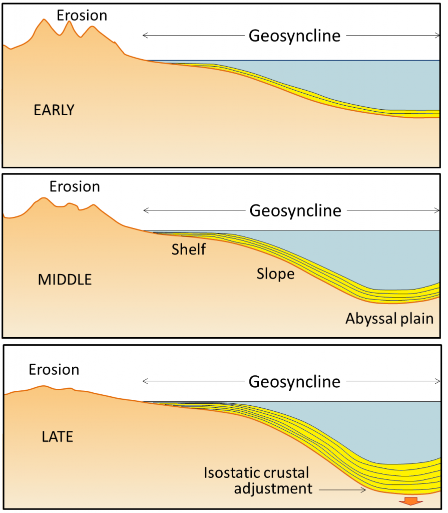
The idea of geosynclines developing into fold-belt mountains originated in the middle of the 19th century, proposed first by James Hall and later elaborated by Dwight Dana, both of whom worked extensively in the Appalachian Mountains of the eastern United States. The process of converting a geosyncline into a mountain belt was never really adequately explained, although it was widely believed that mountain belts formed when geosynclines were compressed by forces pushing from either side. The problem is that, without the lateral forces related to plate tectonics, no one was able to adequately describe what would do the pushing. The sediments that accumulate within a geosyncline are derived from erosion of the adjacent continent. Geosynclinal sediments—which eventually turn into sedimentary rocks—may be many thousands of metres thick. As they accumulate, they push down the pre-existing crustal rocks. Extensive geosynclinal deposits exist around much of the coastline of most of the continents; there is a large geosyncline along the eastern edge of North America.
Proponents of the geosyncline theory of mountain formation—and there were many well into the 1960s—also had the problem of explaining the intercontinental terrestrial fossil matchups. The simple explanation was that there were “land bridges” across the Atlantic along which animals and plants could migrate back and forth. One proponent of this idea was the American naturalist Ernest Ingersoll. Referring to evidence of past climate changes, Ingersoll contributed the following to the Encyclopedia Americana in 1920: “The most interesting feature of these changes, however, is that by which, now and again, the Old World was connected with the New by necks or spaces of land, known as “land-bridges”; especially as these permitted an interchange of plants and animals, giving to us many new ones from the other side of the ocean, including, finally, man himself.”[1]
There are serious problems with the land-bridge theory. One is that it is completely inconsistent with isostasy, and another is that there is no evidence of the remnants of the land bridges. The Atlantic Ocean is several thousand metres deep over wide areas, and so the underwater slopes leading up to a land bridge would have to have been at least tens of kilometres wide in most places, and many times that in others. A land bridge of that size would certainly have left some trace.
The main continents around the Atlantic Ocean are depicted here in the shapes that they might have had during the Mesozoic, including the extents of their continental shelves. Cut these shapes out and see how well you can fit them together in the positions that these areas occupied within Pangea. You can refer to a map of Pangea to help you make the fit.
See Appendix 3 for Exercise 10.1 answers.
Media Attributions
- Figures 10.2.1, 10.2.2: © Steven Earle. CC BY.
- http://en.wikisource.org/wiki/The_Encyclopedia_Americana_(1920)/Land-Bridges_Across_the_Oceans ↵
<!– pb_fixme –>
<!– pb_fixme –>
