1.3 Marine Provinces
Paul Webb
In section 1.2 we learned about the regions that make up the continental margins. So before we leave this topic, we will look at some of the other ways we can categorize the ocean environments.
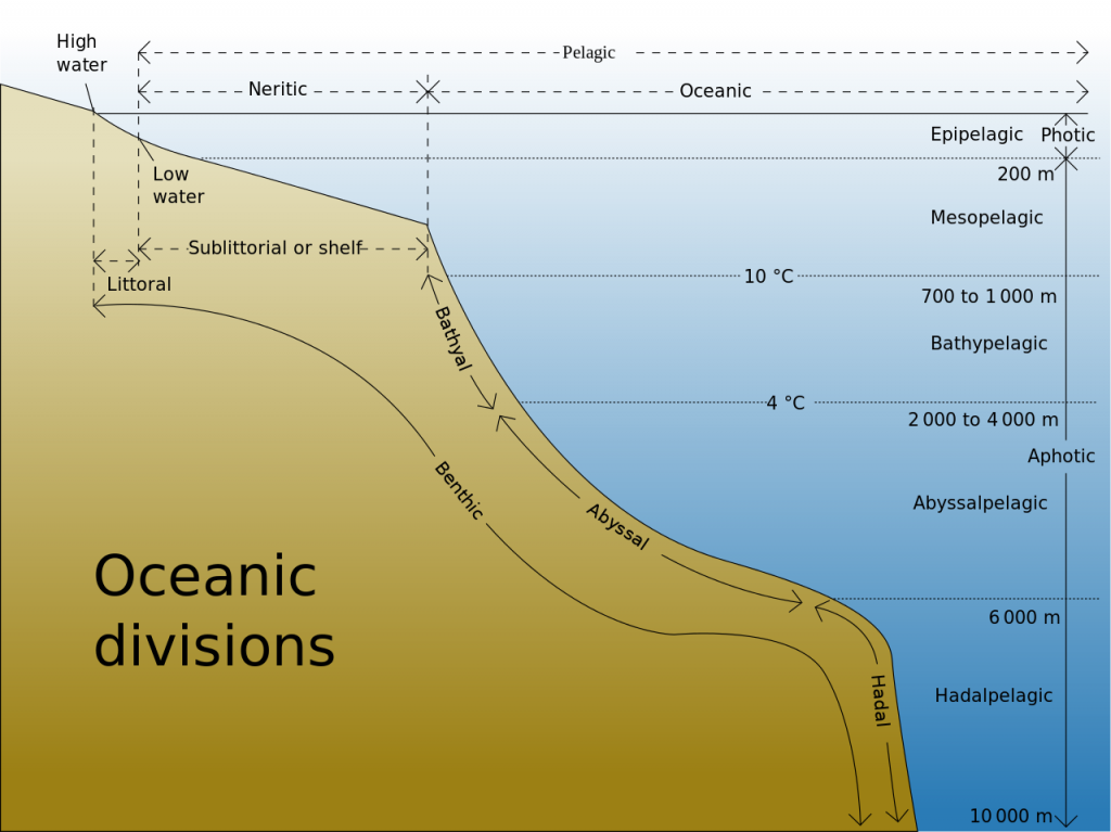
The first major distinction is between the pelagic and benthic zones. The pelagic zone refers to the water column, where swimming and floating organisms live. The benthic zone refers to the bottom, and organisms living on and in the bottom are known as the benthos.
The pelagic zone is divided into two provinces: the neritic province corresponds to all of the water from the low tide line to the shelf break, while the oceanic province represents all of the other water in the open ocean regions.
The oceanic province is divided into depth zones (Figure 1.3.1):
- 0-200 m is the epipelagic zone (“epi” = “upon”, as in on top of the pelagic zone). This is the region where enough light penetrates the water to support photosynthesis (see section 7.3), so it is also called the euphotic or photic zone.
- 200-1000 m is the mesopelagic zone (“meso” = “middle”). There is some light here, but not enough for photosynthesis, so it is called the dysphotic zone, or the twilight zone.
- 1000-4000 m is the bathypelagic zone (“bathy” = “deep”). There is no light at these depths, so it is referred to as the aphotic zone. About 75% of the living space in the ocean lies at these depths or deeper.
- 4000-6000 m is the abyssopelagic or abyssalpelagic zone, which extends to the seafloor in most areas.
- 6000 m and below is the hadopelagic or hadalpelagic zone (named for Hades or “hell”). This refers to the water in deep ocean trenches.
Inhabitants of these regions are referred to according to their habitat, for example mesopelagic fish, or epipelagic squid.

The benthic environment is also divided into zones, most of which correspond to the pelagic divisions:
- The supralittoral zone lies above the high tide line. Also called the spray zone, it is only submerged during storms or unusually high waves.
- The littoral zone is the region between the high and low tides. Thus it is also referred to as the intertidal zone.
- Below the littoral zone is the sublittoral (shelf) zone, extending from the low tide mark to the shelf break, essentially covering the continental shelf.
- The bathyal zone extends along the bottom from the shelf break to 4000m, so it generally includes the continental slope and rise.
- The abyssal zone is found between 4000-6000 m, including most of the abyssal plains. The abyssal zone represents about 80% of the benthic environment.
- The hadal zone includes all benthic regions deeper than 6000 m, such as in the bottom of trenches.
the region of transition from the land to the deep sea floor, i.e. between continental and oceanic crust (1.2)
relating to the open ocean (1.3)
refers to the environment of the seafloor (1.3)
refers to the community of organisms living on or in the ocean floor (1.3)
the marine pelagic province from the low tide line to the shelf break (1.3)
the marine pelagic province representing the open ocean regions, i.e. beyond the neritic zone (1.3)
the upper layer of water (0 to 200 m) in areas of the open ocean (1.3)
the production of organic compounds from carbon dioxide and water, using sunlight as an energy source (5.5)
the upper regions of the ocean where there is enough light to support photosynthesis; approximately 0-200 m; also called the photic zone (1.2)
the upper regions of the ocean where there is enough light to support photosynthesis; approximately 0-200 m; also called the euphotic zone (1.2)
the upper middle zone of the open ocean extending from 200 to 1000 m depth (1.3)
depths of the water column where there is some light penetration, but not enough to support photosynthesis; corresponds to the mesopelagic zone, 200-1000 m. Also known as the twilight zone (1.3)
depths of the water column where there is some light penetration, but not enough to support photosynthesis; corresponds to the mesopelagic zone, 200-1000 m. Also known as the dysphotic zone (1.3)
the moderately deep parts of the open ocean, between 1000 and 4000 m (1.3)
depths beyond 1000 m where there is no light penetration (1.3)
the deeper parts of the open ocean, between 4000 and 6000 m; also known as the abyssalpelagic zone (1.3)
region of the open ocean with water depths greater than 6000 m (1.3)
the region of a coast above the high tide line (1.3)
the region of a coast between the high and low tide lines. Also called the intertidal zone (1.3)
the region of a coast between the high and low tide lines. Also called the littoral zone (1.3)
the region of a coast from the low tide line to the end of the continental shelf (1.3)
the boundary between the continental shelf and continental slope, where the angle of the seafloor begins to get steeper (1.2)
the shallow (typically less than 200 m) and flat sub-marine extension of a continent (1.2)
the region of the seafloor from the shelf break to 4000 m (1.3)
the steeper part of a continental margin, that slopes down from a continental shelf towards the abyssal plain (1.2)
the area at the bottom of the continental slope, where it transitions to the abyssal sea floor (1.2)
the region of the seafloor between 4000-6000 m (1.3)
the flat seafloor of the deep ocean, typically beyond the limits of the continental slopes (1.2)
the region of the seafloor below 6000 m (1.3)

