4.3 Mechanisms for Plate Motion
Modified from "Physical Geology" by Steven Earle*
Paul Webb
In section 4.1 we learned that one of the reasons that Wegener’s ideas of continental drift were initially rejected by the scientific community was that he could not provide a plausible mechanism for plate motion. However, with all that we have learned about the processes occurring in the Earth’s interior since then, there is still some debate about the actual forces that make the plates move. One side in the argument holds that the plates are only moved by the traction caused by mantle convection. The other side holds that traction plays only a minor role and that two other forces, ridge push and slab pull, are more important. Some argue that the real answer lies somewhere in between.
To understand mantle convection, imagine a pot of water on a hot stove. The water at the bottom of the pot near the heat source becomes hot and expands, making it lighter (less dense) than the water above. The hot, low density water rises, and cooler, denser water sinks and flows in from the sides. This water then gets heated and rises, and the cycle continues. This creates a circular pattern of rising and sinking water called a convection cell. (To test this, try sprinkling a few flakes of spice in the center of a rapidly boiling pot of water. The flakes will move outwards to the edge of the pot as warmer water rises and pushes them aside).
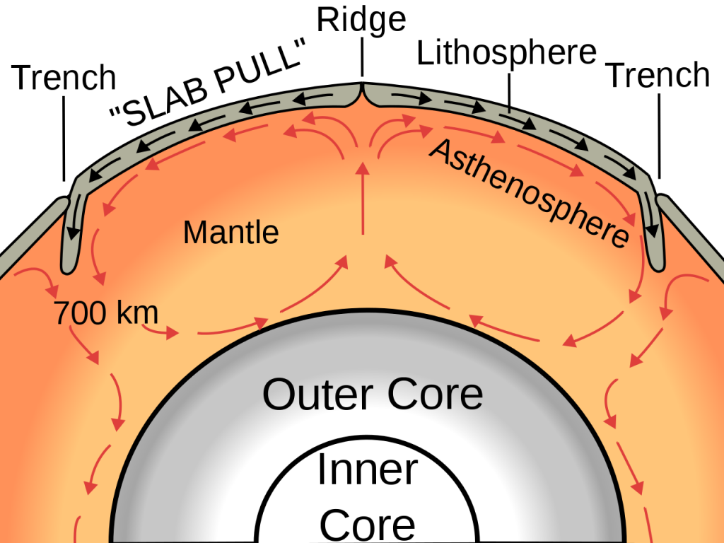
Heat is continuously flowing outward from Earth’s interior, and the transfer of heat from the core to the mantle causes convection in the mantle (Figure 4.3.1). Even though the mantle material is essentially solid rock, it is sufficiently plastic (fluid) to slowly flow (at rates of centimeters per year) as long as a steady force is applied to it. This convection is a driving force for the movement of tectonic plates, as the horizontal movements of mantle under the crust drag the plates with them. At places where convection currents in the mantle are moving upward, new lithosphere forms and the plates move apart (diverge). Where two plates are converging (and the convective flow is downward), one plate will be subducted (pushed down) into the mantle beneath the other.

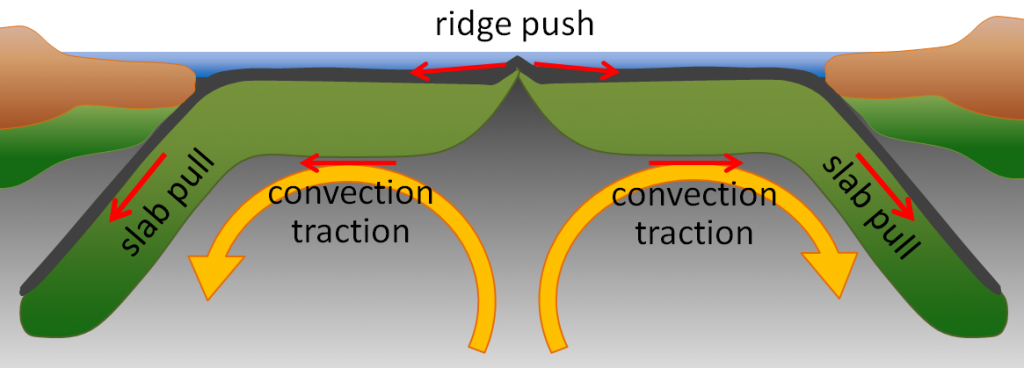
The ridge push/slab pull model also relies on mantle convection, but in this case it is not simply the traction from the convection cell that moves the plates. In this model, plates move through a combination of pull from the weight of the subducting edge of the plates, and through the outward pushing of an ocean ridge where magma is rising and forming new crust (Figure 4.3.2).

Additional links for more information:
- Animation speculating on the movements of the continents over the last 3 billion years…. https://www.youtube.com/watch?v=UwWWuttntio
- And what might happen over the next 300 million years: https://www.youtube.com/watch?v=bQywDr-btz4
*”Physical Geology” by Steven Earle used under a CC-BY 4.0 international license. Download this book for free at http://open.bccampus.ca
the idea that the continents have moved over the surface of the Earth over geological time (4.1)
a region of the lithosphere that is considered to be moving across the surface of the Earth as a single unit (4.1)
movements in the mantle from rising and sinking mantle material as it heats and cools (4.3)
the concept that at least part of the mechanism of plate motion is the push of oceanic lithosphere down from a ridge area (4.3)
the concept that at least part of the mechanism of plate motion is the pull of oceanic lithosphere down into the mantle (4.3)
a rotating region in a fluid in which upward motion of warmer, low density fluid in the center is balanced by downward motion of cooler, denser fluid at the periphery (4.3)
the metallic interior part of the Earth, extending from a depth of 2900 km to the center (3.2)
the middle layer of the Earth, dominated by iron and magnesium rich silicate minerals and extending for about 2900 km from the base of the crust to the top of the core (3.2)
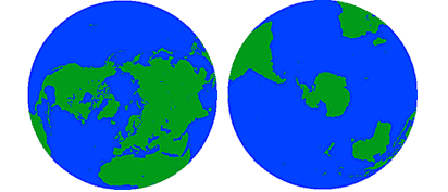
Let's begin by looking at a few basic facts about the oceans. We often think of Earth in terms of its land area, but in reality 71% of the Earth's surface is covered by oceans, while only 29% is land. Oceans cover an area of 139 million miles2or 361 million km2, and contain a volume of about 1.37 billion km3 of water. All of this water is not distributed equally over the Earth; 61% of the Northern Hemisphere is covered by oceans, while in the Southern Hemisphere the oceans cover 81% of the surface area (Figure 1.1.1).

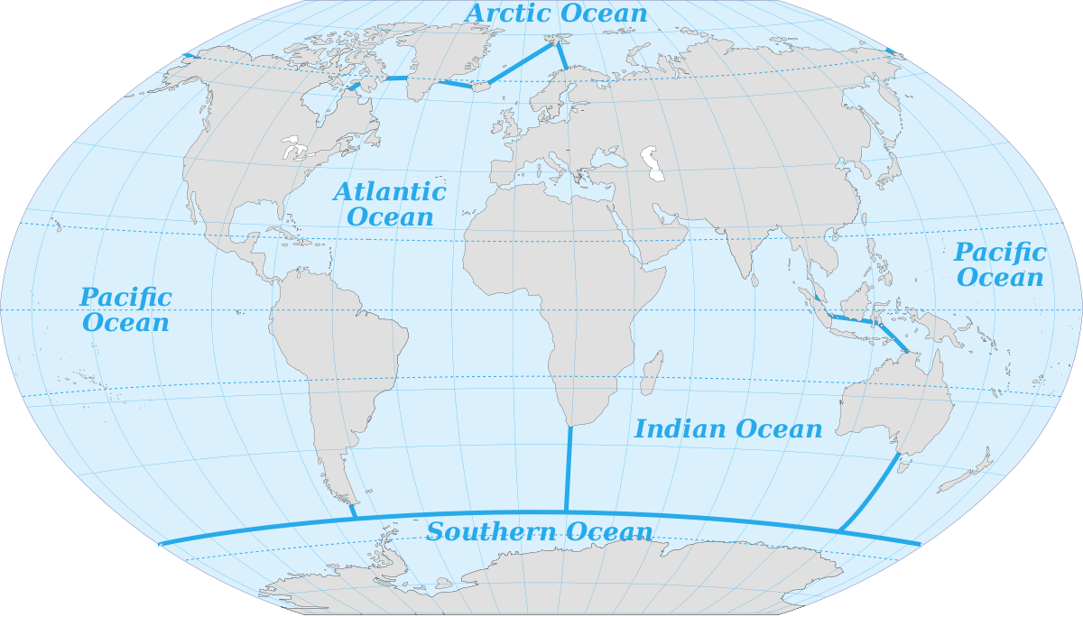
Various sources differ in the number of recognized ocean basins. Historically the major oceans were recognized as the Pacific, Atlantic, Indian, and Arctic Oceans. More recently, the Southern Ocean has been recognized as fifth named ocean, comprising all of the water from the coast of Antarctica to 60o S (Figure 1.1.2). In 2000 these boundaries were submitted to the International Hydrographic Organization for official recognition, but several countries do not recognize it as a separate ocean, but rather as the southern extension of the other major oceans. The Southern Ocean has its own unique characteristics, so for the purposes of this book we will include it as a separate ocean.

The oceans account for vast amounts of water, containing 97% of the water on Earth's surface, with over half of the water in the Pacific alone (Table 1.1.1).
Table 1.1.1 Percentage of Earth's water in various locations
| Pacific | 52% |
| Atlantic | 25% |
| Indian | 20% |
| Ice | 2% |
| Ground water | 0.6% |
| Atmosphere, lakes & rivers | 0.01% |
The average depth of the world ocean is about 3800m (12,500 ft), which is about four times deeper than the average land elevation is high (840m or 2800 ft). In fact Mt. Everest, the highest point on land, is 8848m (29,028 ft) high, while the deepest part of the ocean, the Challenger Deep of the Marianas Trench is approximately 10,920m (36,200 ft) deep. So you could submerge Mt. Everest in the Marianas Trench and it would still be covered by over 2 km of water! Because there is so much more water on Earth than there is land, if you could smooth out the land elevation the entire Earth would still be covered by water about 2700 m deep.
Of the major ocean basins, the Pacific is the largest (almost as large as all of the others combined), and is the deepest (Table 1.1.2).
Table 1.1.2 Area and depth of the major oceans
Watch the video below for some perspective on the size and depth of the oceans.
https://www.youtube.com/watch?v=UwVNkfCov1k
the uppermost layer of the Earth, ranging in thickness from about 5 km (in the oceans) to over 50 km (on the continents) (3.2)
the rigid outer part of the Earth, including the crust and the mantle down to a depth of about 100 km (3.2)
when part of a plate is forced beneath another plate along a subduction zone (4.3)
the part of the mantle, from about 100 to 200 km below surface, within which the mantle material is close to its melting point, and therefore relatively weak (3.2)

