81 Summary — Physical Geology – 2nd Edition
- What aspect of plate tectonics was not included in the Hess theory?
- Figure 10.36 shows the pattern of sea-floor magnetic anomalies in the area of a spreading ridge. Draw in the likely location of the ridge.
- What is a mantle plume and what is its expected lifespan?
- Describe the nature of movement at an ocean ridge transform fault (a) between the ridge segments, and (b) outside the ridge segments.
- How is it possible for a plate to include both oceanic and continental crust?
- What is the likely relationship between mantle plumes and the development of a continental rift?
- Why does subduction not take place at a continent-continent convergent zone?
- Divergent, convergent, and transform boundaries are shown in different colours on Fiugre 10.37. Which colours are the divergent boundaries, which are the convergent boundaries, and which are the transform boundaries?
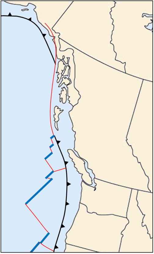 Figure B [Image Description]
Name the plates on this map and show their approximate motion directions.
Show the sense of motion on either side of the plate boundary to the west of Haida Gwaii (Queen Charlotte Islands).
Where are Earth’s most recent sites of continental rifting and creation of new ocean floor?
What is likely to happen to western California over the next 50 million years?
What geological situation might eventually lead to the generation of a subduction zone at a passive ocean-continent boundary such as the eastern coast of North America?
Answers to Review Questions can be found in Appendix 2.
Image Descriptions
Figure B image description: A black line with triangles pointing towards the coast stretches from the Oregon and Washington state up just past Vancouver Island to the southern tip of Haida Gwaii. This line also appears along the Alaskan coast and stretches part way down the Alaskan Pan-Handle. A thin red line stretches from the Alaskan Pan-Handle down just past the southern tip of Haida Gwaii. From that point, it alternates from being a thin red to a thick blue line to form uneven angles zig zagging south past Oregon state. [Return to Figure B]
Media Attributions
- Figures A, B: © Steven Earle. CC BY.
